
Our Cloudiness Map May Improve Your Experience

One of the biggest shows of the summer won’t require a ticket. However, the rare total solar eclipse crossing the country on August 21, from Oregon to South Carolina, must contend with the bane of sun seekers: the potential for cloudy weather.
Historically speaking, cloudiness may factor into each location’s chance for a good viewing. NOAA’s NCEI and the Cooperative Institutes for Climate and Satellites–North Carolina (CICS-NC) reviewed past cloud conditions for August 21. We found that the coasts could be susceptible to cloudier conditions and that increased cloud cover may be possible as the eclipse travels across the country east of the Mississippi River.

The darker the dot, the greater the chance for cloudiness at the hour of peak viewing during the total solar eclipse on August 21, 2017. Dots represent automated weather stations that reported the cloudiness data and show the 10-year cloudiness average for August 21, 2001–2010. Map developed by CICS-NC in cooperation with NOAA NCEI, Deborah Riddle.
Although the picture doesn’t particularly bode well at the coasts of Oregon and South Carolina, the chance for clearer skies appears greatest across the Intermountain West. If historical conditions hold true, Rexburg, Idaho, a two-hour drive west of Wyoming’s Grand Teton National Park, has a good chance for clearer skies. Casper, Wyoming, also holds promise. Other historically clear locations include Lincoln, Nebraska, and Carbondale, Illinois.
Historical cloudiness increases as the path curves southeastward across the Plains, making viewing the rare event potentially rarer as it moves toward the East Coast. This is the first time since 1979 that a total eclipse has crossed the United States and the first time since 1918 that one will travel coast to coast. Everyone in the 50 states will be able to experience at least a partial eclipse, depending on weather, but no other country falls in the path of the total eclipse.
Try Our Interactive Eclipse Map
Our interactive map provides greater detail about viewing the eclipse across the nation. The map lists a “viewable” percentage for each reporting location. The viewable percentage represents the likelihood of skies being clear enough for the eclipse to be visible. A higher percentage means a viewer is more likely to have a view unobstructed by clouds. Also, a bar chart shows the probabilities for five types of cloud cover: clear (no clouds), few, scattered, broken, and overcast. Percentages are derived from averages of each type of cloud cover.
Take Newport, Oregon, for instance, the first land-based weather station location in the path of the full eclipse. The eclipse will occur there at approximately 10:15 a.m. local time (17:15 UTC). The viewable percentage is 44 percent, meaning there’s a 56 percent chance that viewability will be adversely affected by clouds. Keep in mind the percentage is an estimate of average conditions, not a guarantee for this year.
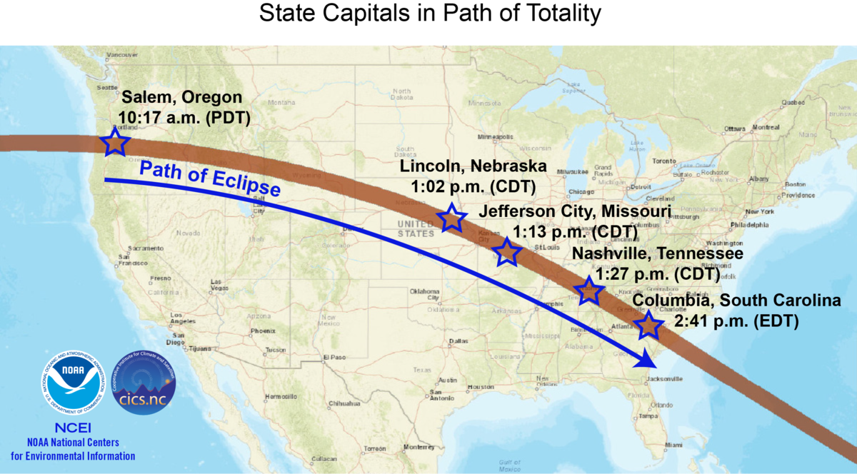
Only an estimated 12 million people live within the relatively narrow area of the total eclipse. However, several major cities and five state capitals fall within the path of totality—the narrow band where the moon completely blocks the sun’s face. Visit the CICS-NC interactive map to search for an optimal viewing location by zip code.
Find a Seat for the Total Eclipse
From its first appearance over the Pacific Northwest in midmorning, the eclipse will last approximately 90 minutes, ending shortly after 2:45 p.m. local time (18:45 UTC) on the South Carolina coast near Charleston. Here’s a partial list of towns and cities on the path of totality from west to east along with estimated local times for peak viewing of the total eclipse, followed by the average historical cloudiness percentage (state capitals in bold; asterisks indicate larger airports):
| State | City | Time | Viewability Percentage |
|---|---|---|---|
| Oregon | Newport | 10:15 a.m. (PDT) | 44% |
| McMinnville | 10:17 a.m. (PDT) | 69% | |
| Salem* | 10:17 a.m. (PDT) | 67% | |
| Idaho | Idaho Falls | 11:32 a.m. (MDT) | 78% |
| Wyoming | Casper* | 11:42 a.m. (MDT) | 88% |
| Nebraska | Alliance | 11:49 a.m. (MDT) | 82% |
| Lincoln* | 1:02 p.m. (CDT) | 77% | |
| Missouri | Kansas City* | 1:07 p.m. (CDT) | 49% |
| Jefferson City | 1:13 p.m. (CDT) | 77% | |
| Chesterfield near St. Louis | 1:16 p.m. (CDT) | 61% | |
| Illinois | Carbondale | 1:19 p.m. (CDT) | 80% |
| Kentucky | Paducah | 1:22 p.m. (CDT) | 77% |
| Bowling Green | 1:27 p.m. (CDT) | 71% | |
| Tennessee | Nashville* | 1:27 p.m. (CDT) | 44% |
| South Carolina | Clemson | 2:37 p.m. (EDT) | 75% |
| Greer* | 2:38 p.m. (EDT) | 65% | |
| Columbia* | 2:41 p.m. (EDT) | 44% | |
| Charleston | 2:45 p.m. (EDT) | 53% |
Total or Partial Eclipse
Besides crossing Oregon, Idaho, Wyoming, and South Carolina, the total eclipse takes a relatively swift and narrow route across portions of Nebraska, Kansas, Missouri, Illinois, Kentucky, Tennessee, and North Carolina. The eclipse crosses directly over five state capitals.
Although skies will dim for many, day will turn to night only beneath the path of totality, approximately 70 miles wide on the surface. The farther away from the path of totality, the less the moon will cover the sun from the viewer’s standpoint. Most people will see a partial eclipse due to their location outside the totality.
The interactive map marks shaded areas on either side of the path of totality that represent the zones where the sun will only be partially blocked or obscured. Each station on the interactive map lists this “obscuration” percentage and the peak eclipse time. A filter can be applied on the map to view each obscuration area independently.
Eclipse Essential: Protect Your Eyes
It’s important to take precautions when viewing the eclipse. The partial phases of the eclipse can last between 2 to 3 hours; at its longest, the total eclipse will last 2 minutes and 40 seconds. Direct viewing of the partial phases can cause permanent damage to your eyes because of the intensity of the sunlight. The eclipse should only be viewed with protective eyewear designated for use during an eclipse. Ordinary sunglasses or 3D glasses lack sufficient protection. Also, avoid viewing through unfiltered cameras, telescopes, binoculars, or other optical devices.
However, if weather cooperates during the few minutes that the sun is completely eclipsed in totality, the brief interval is as safe to view as a full moon.
Understanding the Historical Cloudiness Data
Our historical cloudiness data come from 10-year hourly climate normals for 2001–2010 measured at automated weather stations across the country on August 21, as close to the hour of the eclipse as possible. Availability of data determined the number of usable stations. The period 2001–2010 was chosen because a nationwide network of automated observing stations became operational in 1998. This 10-year timeframe allowed hourly normals computation for more than 800 stations.
However, many factors can influence cloudiness. Areas that experience higher humidity, such as coastal Oregon and the Southeast, are more likely to experience cloudy conditions. Other local factors may influence cloudiness and viewability as well, such as mountains and fog. Afternoon convection can also cause pop-up showers and storms. This helps explain the lower viewable percentages over the eastern half of the United States when the eclipse passes through early to midafternoon.
Keep a few other caveats in mind as you look at our maps. Automated weather stations only view clouds from the surface to 12,000 feet. Larger airports also typically have two cloud sensors (ceilometers) whereas smaller airports may only have one. Larger airports often have human observers that can see higher clouds. These differences mean that stations at larger airports tend to detect more clouds, so stations near each other may report different viewability percentages.
Ultimately, the cloudiness calculations are based on past observations, which are no guarantee of future outcomes. For predictions of actual conditions closer to the day of the eclipse, check your location’s forecast at NOAA's Weather.gov as early as seven days prior to the event.
As Brady Phillips of NOAA’s Office of Communications notes, "Even the driest places on Earth experience clouds, fog, and rain.”
Check Back with NCEI for More Eclipse Coverage
Please check back for an “eclipse weather” story from the early 1900s.


")