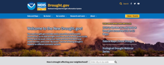
Drought.gov improves its features, usability, and content

Offering new features and improvements, Drought.gov has expanded its usability and scope. The revamped public portal for drought information and data from NOAA and partners builds in more options to understand local conditions and analyze economic impacts of drought and dry conditions across the United States and beyond.
The new site is designed to make information easier to find and use, and adds context about the complexities of drought and drought ecosystems. Drought data users range from farmers, ranchers, and crop growers to federal, tribal, state, and local governments, public and private enterprises, individuals, and researchers.
A Better Drought.gov
The makeover responds to user feedback and the desire to integrate information from partnering organizations into a more holistic view of drought. The updated content and new interactive focus provides actionable, shareable information and easy-to-understand graphics describing current drought conditions and forecasts. Users can access information about conditions at many scales—by county, state, zip code—or for a watershed or international location. Many maps can be zoomed in and provide statistics from the period of record.
The portal, managed in part by NCEI, also compiles and presents drought impact data for economic sectors such as agriculture, energy, water utilities, and recreation using interactive maps and data that don’t exist anywhere else.
Features of Drought.gov that have been added or enhanced include:
- Global drought maps updated every 24 hours
- Higher resolution maps of the county and city level
- Drought ranking data from NCEI
- Paleoclimate data from NCEI going back 2,000 years
- Drought analysis by sector, such as water, agriculture, energy, and more
- Zip code search of drought conditions
- Research and learning resources
- Visualizations of climate indicators
- Historical drought conditions for counties and states
- Highlights from partner organizations
New and revamped elements add more choices and easier navigation for exploring drought information. For instance, one of the most frequently asked questions about drought tends to be: “What are the historical drought conditions in my area?” The new site gives the public the ability to answer that question more easily.
Watch this demonstration video to learn more.
About Drought.gov
Drought.gov, maintained by NOAA’s National Integrated Drought Information System (NIDIS), has become an essential resource to prepare, respond, and cope with the impacts of drought conditions, primarily in the United States. NIDIS is a multi-agency partnership authorized by Congress in 2006 to coordinate drought monitoring, forecasting, planning, and information at federal, tribal, state, and local levels across the country.
Along with Drought.gov, NIDIS is building a national Drought Early Warning System (DEWS).
Many NIDIS partners also contribute to the U.S. Drought Monitor (USDM), a weekly summary of conditions, maps, and data tables, and the North American Drought Monitor (NADM), issued monthly for the United States, Canada, and Mexico. NCEI has contributed to the development of the U.S. Drought Monitor since its launch in 1999. Since then, it has become an essential resource for decision-makers.
For technical or other questions about the new Drought.gov website, please email drought.portal@noaa.gov.


