
The 2010 Deepwater Horizon rig explosion and fire resulted in the most significant offshore oil spill in U.S. history when an estimated 3.2 million barrels of oil escaped into the Gulf of Mexico over 87 days from a damaged wellhead a mile below the surface. Eleven workers were killed, and ecosystems across the Gulf of Mexico suffered.
Scientists from NOAA and many partner agencies stepped in and began the process of collecting data to track oil as it spread across the Gulf. NCEI played a pivotal role in the response by capturing and providing public access to this data in near-real time. This collection provides access to data from the initial Deepwater Horizon response, and new information from monitoring, support and restoration efforts conducted by organizations like the NOAA Office of Response and Restoration.

This data represents in situ data collected from various platforms.
Aircraft
AXBT data and plots from two NOAA aircraft
NOAA42
312 profiles (15 salinity and 297 temperature) collected using 272 AXBT's and 25 AXCTD's from May 8 - July 24, 2010:
Plots | CSV | NetCDF | GTSPP ASCII | Inventory | KMZ
NOAA49
63 temperature profiles collected using 63 AXBT's from May 18 - May 21, 2010:
Plots | CSV | NetCDF | GTSPP ASCII | Inventory | KMZ
Instrument Types
AXBT
A probe dropped from an aircraft that measures the water temperature as it falls. The AXBT falls at a known rate, so that its depth can be inferred from the time lapsed from launch.
AXCTD
An ocean instrument dropped from an aircraft that measures the following variables:
- Pressure: Converted to calculate depth
- Resistance Temperature: Captured with a platinum thermometer
- Conductivity: Used to estimate salinity
Ship
Water temperature and salinity data collected by the NOAA Ship Gordon Gunter.
-
GTSP
-
193 Profiles
- 86 salinity
- 107 temperature (193 total)
- Measured using 21 XBT's and 86 CTD's from April 22 - May 30, 2010
Plots | CSV | NetCDF | GTSPP ASCII | Inventory | kmz
-
Subsurface Oil Monitoring Data
-
Air Temperature, Barometric Pressure, Biological Data, CDOM Fluorescence, Chlorophyll, Conductivity, Continuous Temperature, Current Speed - East/west Component (u), Current Speed - North/south Component (v), Depth - Bottom, Dissolved Oxygen, Fluorescence, Hydrostatic Pressure, Optical, Relative Humidity, Salinity, Salinity - Surface Water, Sea State, Sea Surface Temperature, Secchi, Secchi Depth, Semivolatile Organic Compounds, Sound Velocity, Temperature, Total Petroleum Hydrocarbons (TPH), Volatile Organic Compounds, Water Clarity, Water Density, Wind Direction, Wind Speed
-
Cruise 01
-
Cruise 02
-
About | ADCP | Cruise Documents | CTD | Products
-
Cruise 03
-
About | ADCP | Cruise Documents | CTD | Products
-
Cruise 04
-
About | ADCP | Cruise Documents | CTD | Products
-
Cruise 05
-
About | ADCP | Cruise Documents | Products
-
Cruise 06
-
About | Cruise Documents | CTD | Products
-
Cruise 07
-
About | ADCP | Analytical Chemistry | Cruise Documents | CTD | Products
-
Cruise 08
-
About | Cruise Documents | CTD | Products | SCS
-
Cruise 09
Water temperature and salinity data were collected by the NOAA Ship Nancy Foster.
-
GTSPP Data
-
235 total profiles
- 25 salinity
- 210 temperature
- Measured using 185 XBT’s and 25 CTD’s from July 1- July 18, 2010
Plots | CSV | NetCDF | GTSPP ASCII | Inventory | kmz
-
Subsurface Oil Monitoring Data
-
Air Temperature, Barometric Pressure, CDOM Fluorescence, Conductivity, Current Speed - East/west Component (u), Current Speed - North/south Component (v), Dissolved Oxygen, Fluorescence, Hydrostatic Pressure, Plankton, Relative Humidity, Salinity, Salinity - Surface Water, Sea Surface Temperature, Semivolatile Organic Compounds, Sound Velocity, Temperature, Total Petroleum Hydrocarbons (TPH), Volatile Organic Compounds, Water Density, Wind Direction, Wind Speed
Water temperature data collected by the research vessel F. G. Walton Smith.
-
GTSPP Data
-
41 temperature profiles collected using XBT’s from June 7- June 1o, 2010
Plots | CSV | NetCDF | GTSPP ASCII | Inventory | kmz
-
Subsurface Oil Monitoring Effort
-
CDOM Fluorescence, Conductivity, Dissolved Oxygen, Hydrostatic Pressure, Salinity, Sound Velocity, Temperature, Volatile Organic Compounds, Water Density
-
Cruise 01
-
About | Analytical Chemistry | Cruise Documents | CTD | Products
-
Cruise 02
-
About | Cruise Documents | CTD | Products
Attenuation/Transmission, CDOM Fluorescence, Conductivity, Dissolved Oxygen, Fluorescence, Hydrostatic Pressure, Salinity, Semivolatile Organic Compounds, Sound Velocity, Suspended Solids, Temperature, Total Petroleum Hydrocarbons (TPH), Turbidity, Volatile Organic Compounds, Water Density
-
Cruise 01
-
About | Cruise Documents | CTD | LISST | Products | Tow Fluorometer
-
Cruise 02
-
About | Analytical Chemistry | Cruise Documents | CTD | LISST | Products
-
Cruise 03
-
About | Analytical Chemistry | Cruise Documents | CTD | LISST | Products | Tow Fluorometer
-
Cruise 04
-
About | Analytical Chemistry | Cruise Documents | CTD | LISST | Products
-
Cruise 05
-
About | Analytical Chemistry | Cruise Documents | CTD | LISST | Products
-
Cruise 06
-
About | Analytical Chemistry | Cruise Documents | CTD | LISST | Products
-
Cruise 07
-
About | Analytical Chemistry | Cruise Documents | CTD | LISST | Products
-
Cruise 08
-
About | Analytical Chemistry | Cruise Documents | CTD | LISST | Products
-
Cruise 09
-
About | Analytical Chemistry | Cruise Documents | CTD | LISST | Products
-
Cruise 11
-
About | Analytical Chemistry | Cruise Documents | CTD | LISST | Products
-
Cruise 12
-
About | Analytical Chemistry | Cruise Documents | CTD | LISST | Products
-
Cruise 13
-
About | Analytical Chemistry | Cruise Documents | CTD | LISST | Products
-
Cruise 15
-
About | Analytical Chemistry | Cruise Documents | CTD | LISST | Products
-
Cruise 16
-
About | Analytical Chemistry | Cruise Documents | CTD | LISST
-
Cruise 17
-
About | Analytical Chemistry | Cruise Documents | CTD | LISST
-
Cruise 18
-
About | Analytical Chemistry | Cruise Documents | CTD | LISST
-
Cruise 19
-
About | Analytical Chemistry | Cruise Documents | CTD | LISST
-
Cruise 20
-
About | Cruise Documents | CTD
-
Cruise 21
-
About | Cruise Documents | CTD
-
Cruise 22
CDOM Fluorescence, Conductivity, Dissolved Oxygen, Hydrostatic Pressure, Salinity, Semivolatile Organic Compounds, Sound Velocity, Temperature, Total Petroleum Hydrocarbons (TPH), Volatile Organic Compounds, Water Density
CDOM Fluorescence, Conductivity, Dissolved Oxygen, Fluorescence, Hydrostatic Pressure, Salinity, Sound Velocity, Temperature, Water Density
-
Cruise 01
-
About | Cruise Documents | CTD
-
Cruise 02
-
About | Cruise Documents | CTD
Temperature
-
Cruise 01
-
About | Cruise Documents | CTD
-
Cruise 02
Temperature
-
Cruise 01
-
About | Cruise Documents | CTD
CDOM Fluorescence, Conductivity, Dissolved Oxygen, Hydrostatic Pressure, Salinity, Semivolatile Organic Compounds, Sound Velocity, Temperature, Total Petroleum Hydrocarbons (TPH), Volatile Organic Compounds, Water Density
-
Cruise 01
-
Cruise 02
-
About | Analytical Chemistry | Cruise Documents | CTD | Products
-
Cruise 03
-
About | Analytical Chemistry | Cruise Documents | CTD | Products
-
Cruise 04
-
Cruise 05
-
About | Analytical Chemistry | Cruise Documents | CTD | Products
-
Cruise 06
-
About | Analytical Chemistry | Cruise Documents | CTD | Products
-
Cruise 07
-
About | Analytical Chemistry | Cruise Documents | CTD | Products
-
Cruise 08
-
About | Analytical Chemistry | Cruise Documents | CTD | Products
CDOM Fluorescence, Carbon - Total Organic, Conductivity, Dissolved Oxygen, Hydrostatic Pressure, Metals, Salinity, Sediment Properties, Semivolatile Organic Compounds, Sound Velocity, Temperature, Total Petroleum Hydrocarbons (TPH), Volatile Organic Compounds, Water Density
-
Cruise 01
-
Cruise 02
-
Cruise 03
-
Cruise 04
-
Cruise 05
-
About | Analytical Chemistry | Cruise Documents | CTD | Products | Sediment
CDOM Fluorescence, Conductivity, Dissolved Oxygen, Hydrostatic Pressure, Salinity, Sound Velocity, Temperature, Water Density
-
Cruise 01
-
About | Cruise Documents | CTD
-
Cruise 02
-
About | Cruise Documents | CTD | Products
CDOM Fluorescence, Conductivity, Dissolved Oxygen, Fluorescence, Hydrostatic Pressure, Salinity, Semivolatile Organic Compounds, Sound Velocity, Temperature, Total Petroleum Hydrocarbons (TPH), Volatile Organic Compounds, Water Density
Attenuation/Transmission, CDOM Fluorescence, Carbon - Total Organic, Conductivity, Dissolved Oxygen, Hydrostatic Pressure, Metals, Salinity, Sediment Properties, Semivolatile Organic Compounds, Sound Velocity, Suspended Solids, Temperature, Total Petroleum Hydrocarbons (TPH), Volatile Organic Compounds, Water Density
-
Cruise 01
-
About | Cruise Documents | CTD | LISST | Products
-
Cruise 02
-
About | Analytical Chemistry | Cruise Documents | CTD | LISST | Products
-
Cruise 03
-
About | Analytical Chemistry | Cruise Documents | CTD | LISST | Products
-
Cruise 04
-
About | Analytical Chemistry | Cruise Documents | CTD | LISST | Products
-
Cruise 05
-
About | Analytical Chemistry | Cruise Documents | CTD | LISST | Products
-
Cruise 06
-
About | Analytical Chemistry | Cruise Documents | CTD | LISST | Products
-
Cruise 07
-
About | Analytical Chemistry | Cruise Documents | CTD | LISST | Products
-
Cruise 08
-
About | Analytical Chemistry | Cruise Documents | CTD | LISST | Products
-
Cruise 09
-
About | Analytical Chemistry | Cruise Documents | CTD | LISST | Products
-
Cruise 10
-
About | Analytical Chemistry | Cruise Documents | CTD | LISST | Products
-
Cruise 11
-
About | Analytical Chemistry | Cruise Documents | CTD | LISST | Products
-
Cruise 12
-
| Analytical Chemistry | Cruise Documents | CTD | LISST | Products
-
Cruise 13
-
About | Analytical Chemistry | Cruise Documents | CTD | LISST | Products
-
Cruise 14
-
About | Analytical Chemistry | Cruise Documents | CTD | LISST | Products
-
Cruise 15
-
About | Analytical Chemistry | Cruise Documents | CTD | LISST | Products
-
Cruise 16
-
About | Analytical Chemistry | Cruise Documents | CTD | LISST | Products
-
Cruise 17
-
About | Analytical Chemistry | Cruise Documents | CTD | Products
-
Cruise 18
-
About | Analytical Chemistry | Cruise Documents | CTD | Products
-
Cruise 19
-
About | Analytical Chemistry | Cruise Documents | CTD | Products
-
Cruise 20
-
About | Analytical Chemistry | Cruise Documents | CTD | Products
-
Cruise 21
-
About | Analytical Chemistry | Cruise Documents | CTD | Products | Sediment
CDOM Fluorescence, Conductivity, Dissolved Oxygen, Hydrostatic Pressure, Salinity, Sound Velocity, Temperature, Water Density
-
Cruise
CDOM Fluorescence, Conductivity, Dissolved Oxygen, Fluorescence, Hydrostatic Pressure, Salinity, Sediment Properties, Sound Velocity, Temperature, Turbidity, Water Density
-
Cruise 01
-
Cruise 02
-
Cruise 03
-
About | Cruise Documents | CTD
-
Cruise 04
-
About | Cruise Documents | CTD
-
Cruise 05
-
About | Cruise Documents | CTD
-
Cruise 06
-
About | Cruise Documents | CTD | Products | Sediment | Tow Cam CTD
-
Cruise 01
CDOM Fluorescence, Carbon - Total Organic, Conductivity, Dissolved Oxygen, Fluorescence, Hydrostatic Pressure, Metals, Methane, Salinity, Sediment Properties, Semivolatile Organic Compounds, Sound Velocity, Temperature, Total Petroleum Hydrocarbons (TPH), Volatile Organic Compounds, Water Density
-
Cruise 01
-
About | Cruise Documents | Hydrocarbon Sensor Array | Products
-
Cruise 02
-
About | Cruise Documents | Hydrocarbon Sensor Array | Products
-
Cruise 03
-
About | Cruise Documents | Hydrocarbon Sensor Array | Products
-
Cruise 04
-
About | Cruise Documents | Hydrocarbon Sensor Array | Products
-
Cruise 05
-
About | Cruise Documents | Hydrocarbon Sensor Array | Products
-
Cruise 06
-
About | Cruise Documents | Hydrocarbon Sensor Array | Products
-
Cruise 07
-
About | Cruise Documents | CTD | Hydrocarbon Sensor Array | Products
-
Cruise 08
-
About | Cruise Documents | Hydrocarbon Sensor Array | Products
-
Cruise 09
-
About | Cruise Documents | Hydrocarbon Sensor Array | Products
-
Cruise 10
-
About | Cruise Documents | Hydrocarbon Sensor Array | Products
-
Cruise 11
-
About | Cruise Documents | Hydrocarbon Sensor Array | Products
-
Cruise 12
-
About | Cruise Documents | Hydrocarbon Sensor Array | Products
-
Cruise 13
-
About | Cruise Documents | Hydrocarbon Sensor Array | Products
-
Cruise 14
-
About | Cruise Documents | CTD | Hydrocarbon Sensor Array | Products
-
Cruise 15
-
About | Cruise Documents | CTD | Hydrocarbon Sensor Array | Products
-
Cruise 16
-
About | Analytical Chemistry | Cruise Documents | CTD | Products
-
Cruise 17
-
About | Analytical Chemistry | Cruise Documents | CTD | Products
-
Cruise 18
-
About | Analytical Chemistry | Cruise Documents | CTD | Products | Sediment
CDOM Fluorescence, Conductivity, Dissolved Oxygen, Fluorescence, Hydrostatic Pressure, Salinity, Sound Velocity, Temperature, Water Density
-
Cruise 01
-
Cruise 02
-
About | Cruise Documents | CTD | MVP | Products
-
Cruise 03
-
About | Cruise Documents | CTD
-
Cruise 01
-
About | Cruise Documents | CTD
CDOM Fluorescence, Conductivity, Dissolved Oxygen, Hydrostatic Pressure, Salinity, Semivolatile Organic Compounds, Sound Velocity, Temperature, Total Petroleum Hydrocarbons (TPH), Volatile Organic Compounds, Water Density
Other Platform
The Development Driller III (DD3) semisubmersible drilling rig was deployed to the site of the Deepwater Horizon Oil Spill incident to assist in drilling a relief well. While on station, the DD3 utilized an Acoustic Doppler Current Profiler (ADCP) that used sonar to measure and record water current velocities, distribution of suspended material over a range of depths, and help predict Loop Eddy current interactions and forces on the platform. This record is a summary of ADCP data that the Development Driller 3 collected from May 31, 2010 - July 04, 2010. This data is raw and unprocessed. Available data types include: Current Speed - East/West Component (u), Current Speed - North/South Component (v).
The Discoverer Enterprise (DE) ultra-deepwater drillship was deployed to the Deepwater Horizon Oil Spill incident site to help collect spilled oil. While on station, the DE utilized an Acoustic Doppler Current Profiler (ADCP) that used sonar to measure and record water current velocities, distribution of suspended material over a range of depths, and help predict Loop Eddy current interactions and forces on the platform. This record is a summary of ADCP data that the Discoverer Enterprise collected from May 23, 2010 - July 04, 2010. This data is raw and unprocessed. Available data types include: Current Speed - East/west Component (u), Current Speed - North/south Component (v).
These files include data from several vessels, including one aircraft survey. Surveys were posted to the GTS as unidentified vessels, so all the call signs are set to "SHIP".
SHIP collected 276 profiles (91 salinity, 185 temperature) using 61 XBT's and 124 CTD's from April 22 - July 24, 2010:
Plots | CSV | NetCDF | GTSPP ASCII | Inventory | KMZ
This data quantifies the Deepwater Horizon Spill's impact on marine life in the Gulf of Mexico.
Fishery Closures and Openings
These maps and data represent the Emergency Fishery Closures and Openings in the Gulf of Mexico due to the Deepwater Horizon Oil Spill.
ESRI GIS File Types
- .dbf: Attribute information
- .lyr: Display information
- .prj: Projection information
- .sbn: Spatial indexing
- .sbx: Spatial indexing
- .shp: Geometrical information (i.e., the main file)
- .shx: Indexing information
ESRI Metadata Files
- .htm: FGDC metadata containing the ESRI profile in Hyper Text Markup Language
- shp.xml: FGDC metadata containing the ESRI profile in Extensible Markup Language
Fishery Closures Data by Date
Changes to the fisheries closure regulatory boundaries are documented below. The files are organized by the date that they were made publicly available.
October 22, 2010
GIS Data Files: .dbf | .lyr | .prj | .sbn | .sbx | .shp | .shx ( .htm, shp.xml)
October 15, 2010
GIS Data Files: .dbf | .lyr | .prj | .sbn | .sbx | .shp | .shx ( .htm, shp.xml)
October 5, 2010
GIS Data Files: .dbf | .lyr | .prj | .sbn | .sbx | .shp | .shx ( .htm, shp.xml)
Supporting Documentation: Map.pdf | Samplingmap.pdf | Monitoringdata.pdf | FDA Concurrence Letter.pdf | FDA Memo.pdf
October 1, 2010
GIS Data Files: .dbf | .lyr | .prj | .sbn | .sbx | .shp | .shx ( .htm, shp.xml)
Supporting Documentation: Map.pdf | Samplingmap.pdf | Monitoringdata.pdf | Monitoringdata 2.pdf | FDA Concurrence Letter.pdf | FDA Memo.pdf
September 21, 2010
GIS Data Files: .dbf | .lyr | .prj | .sbn | .sbx | .shp | .shx ( .htm, shp.xml)
Supporting Documentation: Map.pdf | Samplingmap.pdf | Monitoringdata.pdf | Concurrence Letter.pdf | FDA Memo.pdf
September 3, 2010
GIS Data Files: .dbf | .lyr | .prj | .sbn | .sbx | .shp | .shx ( .htm, shp.xml)
Supporting Documentation: Map.pdf | Samplingmap.pdf | Monitoringdata.pdf | Concurrence Letter.pdf | FDA Memo.pdf
September 2, 2010
GIS Data Files: .dbf | .lyr | .prj | .sbn | .sbx | .shp | .shx ( .htm, shp.xml)
Supporting Documentation: Map.pdf | Samplingmap.pdf | Monitoringdata.pdf | Concurrence Letter.pdf | FDA Memo.pdf | Appendix A Control Assessment
August 27, 2010
GIS Data Files: .dbf | .lyr | .prj | .sbn | .sbx | .shp | .shx ( .htm, shp.xml)
Supporting Documentation: Map.pdf | Samplingmap.pdf | Monitoringdata.pdf | Concurrence Letter.pdf | FDA Memo.pdf | Chemistry explanation
August 10, 2010
GIS Data Files: .dbf | .lyr | .prj | .sbn | .sbx | .shp | .shx ( shp.xml)
Supporting Documentation: Map.pdf | Samplingmap.pdf | Monitoringdata.pdf | PAHLetter.pdf | Concurrence Letter.pdf | FDA Memo.pdf | Chemistry explanation
July 22, 2010
GIS Data Files: .dbf | .lyr | .prj | .sbn | .sbx | .shp | .shx ( .htm, shp.xml)
Supporting Documentation: Map.pdf | Samplingmap.pdf | Samplingmap2.pdf | Monitoringdata.pdf | Monitoringdata2.pdf | Concurrence Letter.pdf | FDA Memo.pdf | Protocol.pdf | PAHLetter.pdf | Chemistry explanation
July 13, 2010
GIS Data Files: .dbf | .lyr | .prj | .sbn | .sbx | .shp | .shx ( .htm, shp.xml)
Supporting Documentation: Map.pdf
July 12, 2010
GIS Data Files: .dbf | .lyr | .prj | .sbn | .sbx | .shp | .shx ( shp.xml)
Supporting Documentation: Map.pdf
July 4, 2010
GIS Data Files: .dbf | .lyr | .prj | .sbn | .sbx | .shp | .shx ( .htm, shp.xml)
Supporting Documentation: Map.pdf
June 28, 2010
GIS Data Files: .dbf | .lyr | .prj | .sbn | .sbx | .shp | .shx ( .htm, shp.xml)
Supporting Documentation: Map.pdf
June 23, 2010
GIS Data Files: .dbf | .lyr | .prj | .sbn | .sbx | .shp | .shx ( .htm, shp.xml)
Supporting Documentation: Map.pdf
June 21, 2010
GIS Data Files: .dbf | .lyr | .prj | .sbn | .sbx | .shp | .shx ( .htm, shp.xml)
Supporting Documentation: Map.pdf
June 16, 2010
GIS Data Files: .dbf | .lyr | .prj | .sbn | .sbx | .shp | .shx ( .htm, shp.xml)
Supporting Documentation: Map.pdf
June 7, 2010
GIS Data Files: .dbf | .lyr | .prj | .sbn | .sbx | .shp | .shx ( .htm, shp.xml)
Supporting Documentation: Map.pdf
June 5, 2010
GIS Data Files: .dbf | .lyr | .prj | .sbn | .sbx | .shp | .shx ( .htm, shp.xml)
Supporting Documentation: Map.pdf
June 4, 2010
GIS Data Files: .dbf | .lyr | .prj | .sbn | .sbx | .shp | .shx ( .htm, shp.xml)
Supporting Documentation: Map.pdf
June 2, 2010
GIS Data Files: .dbf | .lyr | .prj | .sbn | .sbx | .shp | .shx ( .htm, shp.xml)
Supporting Documentation: Map.pdf
June 1, 2010
GIS Data Files: .dbf | .lyr | .prj | .sbn | .sbx | .shp | .shx ( .htm, shp.xml)
Supporting Documentation: Map.pdf
May 31, 2010
GIS Data Files: .dbf | .lyr | .prj | .sbn | .sbx | .shp | .shx ( .htm, shp.xml)
Supporting Documentation: Map.pdf
May 28, 2010
GIS Data Files: .dbf | .lyr | .prj | .sbn | .sbx | .shp | .shx ( .htm, shp.xml)
Supporting Documentation: Map.pdf
May 25, 2010
GIS Data Files: .dbf | .lyr | .prj | .sbn | .sbx | .shp | .shx ( .htm, shp.xml)
Supporting Documentation: Map.pdf
May 21, 2010
GIS Data Files: .dbf | .lyr | .prj | .sbn | .sbx | .shp | .shx ( .htm, shp.xml)
Supporting Documentation: Map.pdf
May 18, 2010
GIS Data Files: .dbf, .lyr, .prj, .sbn, .sbx, .shp, .shx ( .htm, shp.xml)
Supporting Documentation: Map.pdf
May 17, 2010
GIS Data Files: .dbf | .lyr | .prj | .sbn | .sbx | .shp | .shx ( .htm, shp.xml)
Supporting Documentation: Map.pdf
May 14, 2010
GIS Data Files: .dbf | .lyr | .prj | .sbn | .sbx | .shp | .shx ( .htm, shp.xml)
Supporting Documentation: Map.pdf
May 12, 2010
GIS Data Files: .dbf | .lyr | .prj | .sbn | .sbx | .shp | .shx ( .htm, shp.xml)
Supporting Documentation: Map.pdf
May 11, 2010
GIS Data Files: .dbf | .lyr | .prj | .sbn | .sbx | .shp | .shx ( .htm, shp.xml)
Supporting Documentation: Map.pdf | Emergency Closure.pdf
May 7, 2010
GIS Data Files: .dbf | .lyr | .prj | .sbn | .sbx | .shp | .shx ( .htm, shp.xml)
Supporting Documentation: Map.pdf | Emergency Closure.pdf
May 2, 2010
GIS Data Files: .dbf | .lyr | .prj | .sbn | .sbx | .shp | .shx ( .htm, shp.xml)
Supporting Documentation: Map.pdf | Emergency Closure.pdf
Strandings Datasets
Verified observations of dead or debilitated animals found ashore or in the water. Stranded animals are externally swabbed for oil residue and, when possible, tissue samples are collected to assess the potential role of oil exposure. Search and rescue operations are conducted by NOAA, the Florida Fish and Wildlife Conservation Commission, and other partners.
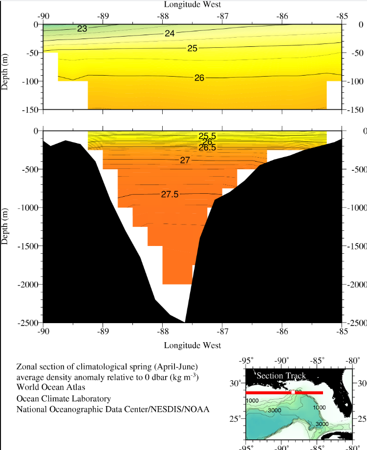
Density relative to 0 dbar (kg/m3)
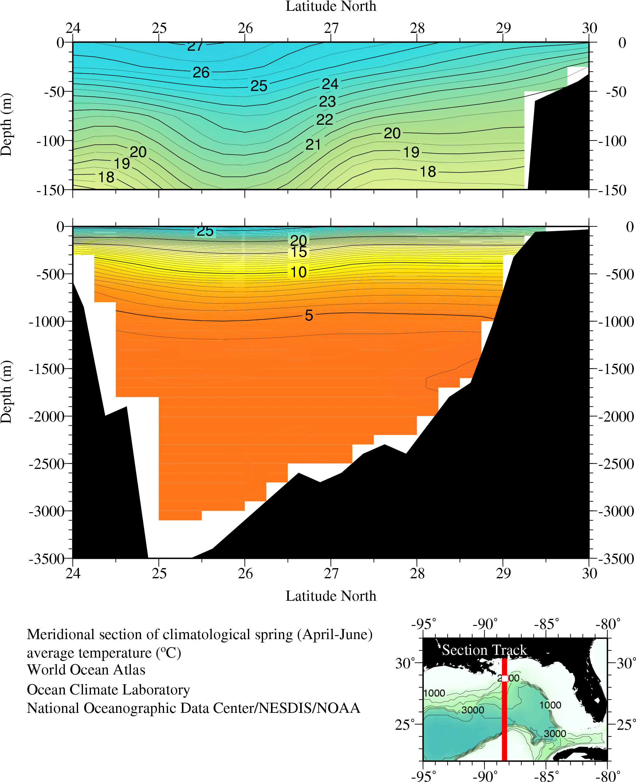
Temperature (°C)
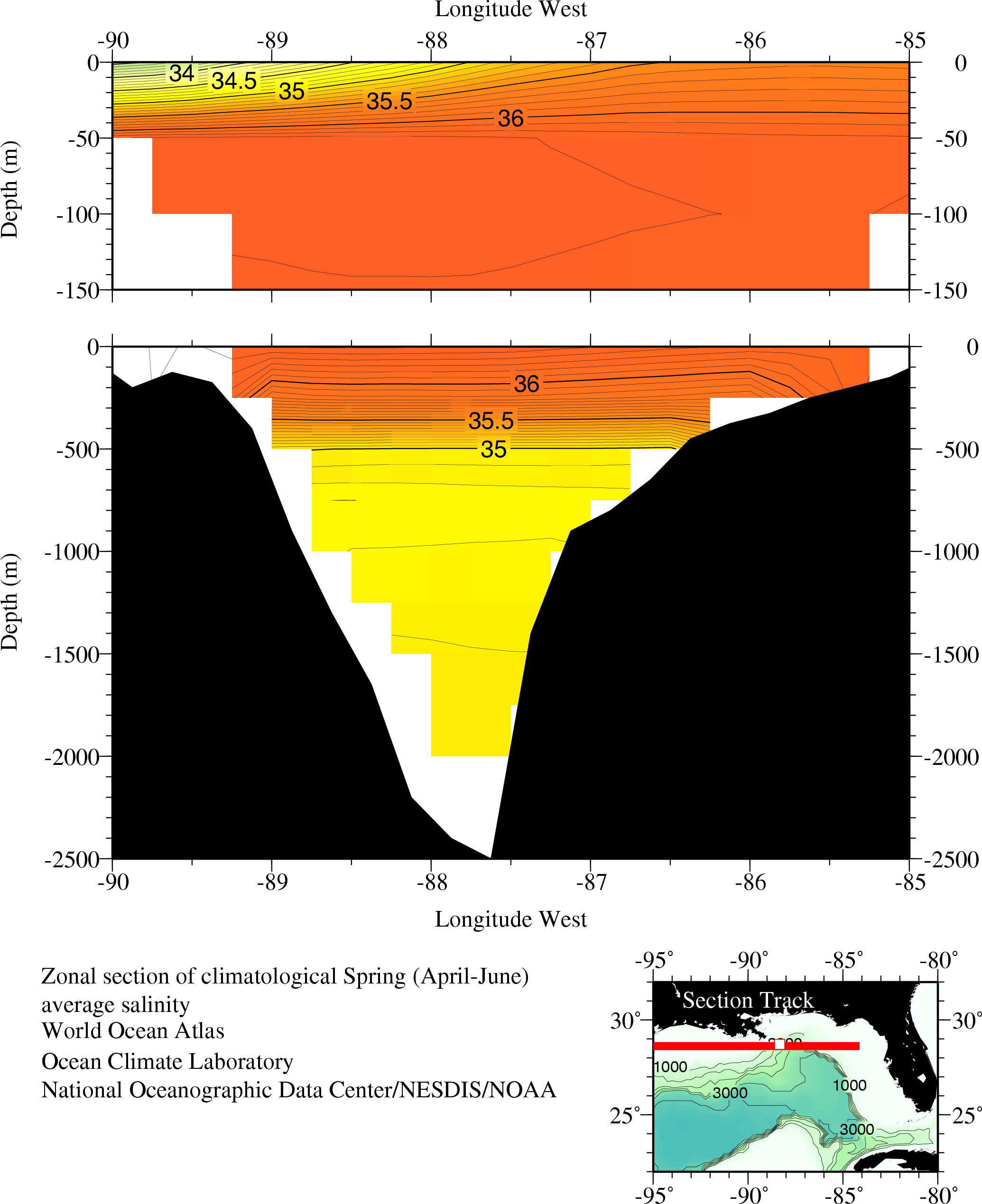
Salinity
Climatologies & Data
-
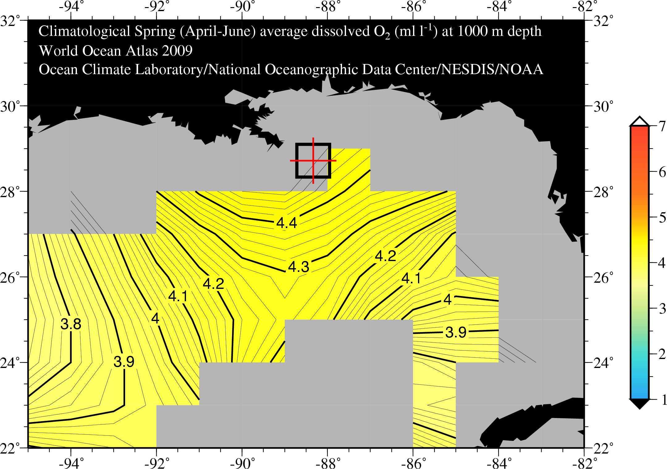
A set of mean fields for temperature, salinity, oxygen, phosphate, silicate, and nitrate.
-
Can be queried for in situ measured temperature, salinity, oxygen, nutrients, pressure, pH, alkalinity, CO2, plankton, chlorophyll, and many more in the Gulf of Mexico, including searching by instrument types.
Interactive Maps
Ocean Currents Data
Moored Buoy: Time Series
Historical time series data in the Gulf of Mexico (18°-31°N, 80°-98°W) in comma separated value (CSV) files for each station. The time series data, collected between 1975 and 1993, includes ocean currents, temperature, salinity, and pressure measured typically at successive times, spaced at uniform time intervals.
Other Projects and Information
- Historical Buoy Data, Eastern and Western Gulf of Mexico: water temp, wind speed, air temp, wave data, pressure
- Coral Reef Information System (CoRIS), Flower Garden Banks
- Joint Archive for Shipboard ADCP (Acoustic Doppler Current Profiler)
- Data and Information collected from support of the IXTOC oil spill incident in 1979
- Environmental Sensitivity Index (ESI) Atlas, Gulf of Mexico, Upper Coast of Texas 1996, Louisiana 2003, Mississippi 2009, Alabama 2007, Florida 1995-2003 maps and geographic information systems data. ESI is a widely used approach to sensitive environment mapping in the U.S.
- Gulf of Mexico Offshore Monitoring Experiment (GOOMEX): marine chemistry, fish & shell-fish surveys, benthic organisms, pollutants, and current meter data.
- CHEMO II: Stability and Change in Gulf of Mexico Chemosynthetic Communities.
Resources on Oil Spills, Response, and Restoration
This collection includes print and media resources pertaining to the Deepwater Horizon oil spill disaster in the Gulf of Mexico, and information on previous spills and associated remedial actions selected from the online NOAA Library and Information Network Catalog (NOAALINC).
The content of the Bibliography includes information sources concerned both with the harmful effects of oil and chemical spills to marine habitats, their associated living marine resources and the cultural and economic impacts of such spills.
The bibliography below attempts to list all of the published research and expert commentary that has resulted from the Deepwater Horizon oil spill. It includes peer-reviewed journal articles and book chapters, technical reports released by scientific agencies and research institutions, and editorials published in peer-reviewed journals.
The NOAA Institutional Repository (IR) includes a collection of Deepwater Horizon Materials. This searchable, online collection includes information from NCEI, libraries, and websites, as well as from federal and state partners.
Datasets compiled by organizations that contributed to the Deepwater Horizon Oil Spill Response.
Quality Controlled Analytical Chemistry Data
This collection includes quality controlled data from the Deepwater Horizon (DWH) Oil Spill Event Response Phase compiled by Federal and state environmental management agencies, as well as BP and its contractors from April, 2010 to June, 2011. These data represent the culmination of a quality-control process overseen by NOAA.
Data were originally uploaded into the EPA Scribe data management system (see Scribe Database Collection, this page), and later transferred to NOAA’s Query Manager system for final evaluation. This collection consists of extractions from Query Manager, and supersedes the Scribe Database Collection.
Content
Commonwealth Scientific and Industrial Research Organization (CSIRO)
CSIRO data collected during the response to the Deepwater Horizon incident in the Gulf of Mexico onboard the M/V Ryan Chouest Cruise 1 through Cruise 15 from June 5, 2010 to September 14, 2010 (Accession 0086283).
Structured Data
CSIRO Shipboard Measurements: CTD vertical profiles, towed fluorometry, onboard hydrocarbon sensors and GCMS data.
Unstructured Data
DFO Canada Database
Data collected by Centre for Offshore Oil Gas and Energy Research (COOGER) and Fisheries and Oceans Canada (DFO) at-sea monitoring operations on board vessels R/V Brooks McCall and R/V Ocean Veritas. From May 8 through August 24, 2010 the DFO COOGER team maintained a continuous monitoring program that recovered a total of 3197 unique water samples from 404 stations at depths down to 2000 m for analysis of dispersant effectiveness by characterizing oil droplet size and UV-fluorescence. This collection of data is organized into nine database tables which include all data used by COOGER to conduct analyses, including:
- LISST data for in situ deployments;
- discrete LISST data collected aboard R/V Brooks McCall and R/V Ocean Veritas;
- UV Fluorescence data collected aboard the R/V Brooks McCall and R/V Ocean Veritas;
- Hydrocarbon chemistry data;
- CTD trace data;
- CTD trace data matched to Niskin bottles;
- R/V Brooks McCall and R/V Ocean Veritas sampling station data (date, depth, location, and distance from wellhead); and
- Wellhead data including daily oil flow and recovery, and dispersant application data.
DFO Canada Database Datasets | Documentation
Scribe Database Collection
The Scribe Database Collection includes 14 databases containing data from the Deepwater Horizon (DWH) Oil Spill Event Response Phase. These databases are the work of Federal agencies, state environmental management agencies and BP and its contractors. Information types include locations, descriptions, and analysis of water, sediment, oil, tar, dispersant, air and other environmental samples. Note: the water and sediment chemistry data from these databases has been extracted by cruise and archived separately in association with the other cruise-related data accessions. See the DWH Ocean In Situ Data page for access to those accessions.
Environmental Protection Agency
Project 1082 DW_Reporting: Database Files | ZIP Package
Environmental Protection Agency Region 06
Project 1112 BP_DW_Sampling_Analytical: Database Files | ZIP Package
National Park Service
Project 1133 NPS_DW_Sampling_Analytical: Database Files | ZIP Package
National Oceanic and Atmospheric Administration
Project 1219 NOAA NOAADW: Database Files | ZIP Package
US Geological Survey
Project 1260 USGSDW: Database Files | ZIP Package
Alabama Department of Environmental Monitoring
Project 1119 ADEM_DW_Sampling_Analytical_Monitoring: Database Files | ZIP Package
Alabama EnviroChem, Inc.
Project 1134 ALECI_DW_Sampling_Analytical: Database Files | ZIP Package
Florida Department of Environmental Protection
Project 1130 FLDEP_DW_Sampling_Analytical: Database Files | ZIP Package
Louisiana Department of Environmental Quality
Project 1113 LDEQ_DW_Sampling_Analytical LDEQ: Database Files | ZIP Package
Mississippi Department of Environmental Quality
Project 1122 MSDEQ_DW_Sampling_Analytical: Database Files | ZIP Package
Center for Toxicology and Environmental Health
- Project 1120 CTEH_DW_Monitoring: Database Files | ZIP Package
- Project 1300 CTEH_DW_Sampling_Analytical:Database Files | ZIP Package
Environmental Standards Inc.
Project 1302 EnvStds_DW_Sampling_Analytical_2: Database Files | ZIP Package
JAG Subsurface Dispersed Oil and Oxygen Levels
The Deepwater Horizon Joint Analysis Group (JAG) for Surface and Sub-Surface Oceanography, Oil and Dispersant Data was a working group with membership from federal agencies, BP, and academia that was formed to analyze sub-surface oceanographic data being derived from the ongoing coordinated sampling as part of the spill response. JAG was created to provide comprehensive characterization of the Gulf of Mexico sub-surface conditions as well as the fate and transport of dispersed petroleum as a result of the Deepwater Horizon oil spill. JAG findings were published in a series of reports for the Unified Area Command as well as the public. This accession contains Total Petroleum Hydrocarbon and Volatile Organic Analysis data from laboratory analysis, as well as in situ Chromophoric Dissolved Organic Matter and dissolved oxygen data. This dataset was compiled as part of the final JAG summary report, and referred to in Appendix 3 of that report, NOAA Technical Report NOS OR&R 27 (2012).
Citation for JAG summary report: Joint Analysis Group, Deepwater Horizon Oil Spill (2011). Review of Subsurface Dispersed Oil and Oxygen Levels Associated with the Deepwater Horizon MC252 Spill of National Significance. NOAA Technical Report NOS OR&R 27. The report itself may be accessed through the NOAA Central Library.
Content
JAG Analytical Chemistry Table | JAG CTD Summary Table
Ship Instruments
Conductivity-Temperature-Depth (CTD)
An ocean instrument includes a pressure sensor (measured pressure is converted to depth), a resistance temperature measurement device (usually a platinum thermometer), and a conductivity sensor used to estimate salinity. CTDs are usually mounted on a metal frame and lowered through the water column suspended from a cable. Example CTD Plot.
eXpendable BathyThermograph (XBT)
A probe that measures water temperature as it falls. A very thin wire transmits the temperature data to the ship where it is recorded for later analysis. The probe is designed to fall at a known rate, so that the depth of the probe can be inferred from the time lapsed from launch.
Acoustic Doppler Current Profiler (ADCP)
This instrument measures currents beneath a ship while underway. Sound signals sent from the moving ship bounce back to receivers aboard the ship. This provides a profile of water movement relative to the ship-precise modern navigation, allowing the ship's motion to be subtracted from the data. These devices are also used on moorings and profilers and, along with acoustic backscattering, measure animal biomass. Particles in the path of the sound waves, mostly plankton, reflect a small part of the sound energy back toward receivers, allowing researchers to make remote estimates of the sizes and numbers of animals present in the water column. The Lowered Acoustic Doppler Current Profiler (LADCP) is an ADCP which can be lowered on a cable from the surface.
Hydrocarbon Sensor Array
A sensor platform developed by the Commonwealth Scientific and Industrial Research Organisation (CSIRO), Australia's national science agency, for detecting different types of hydrocarbons at varying sensitivities, and in real time. The platform consists of a number of hydrocarbon sensors assembled to produce a highly sensitive and discriminatory hydrocarbon sensor capability designed to detect and differentiate hydrocarbons in a marine environment. The platform enables environmental monitoring, studying of ocean changes and the measurement of human impacts on marine environments.
Laser In Situ Scattering and Transmissometer (LISST)
An instrument that measures the size distribution of particles 5 to 250 microns in diameter. LISST generates diagrams of the size distribution of particles and small aggregates in the water column without disturbing them by collecting them in water bottles. Particles' sizes influence their optical properties and settling dynamics, but many of the aggregates fall apart in water bottles before they can be returned to the lab and measured.
Multiple Opening/Closing Net and Environmental Sensing System (MOCNESS)
A net system for measuring plankton in the ocean. The MOCNESS is towed behind a research vessel at low speed and consists of numerous nets of varying mesh sizes. Each net can be opened and shut independently so that it samples a discrete patch of water. The net enables biologists to catch zooplankton and nekton in various depth horizons typically anywhere in the upper 500 m of the oceans. There is also an array of sensors mounted on the instrument frame that relays water conditions up to the ship in real time, typically including CTD, PAR (photosynthetically available light), transmissometry and fluorescence sensors. The sensor data help researchers match what they find in their samples to the physical properties of the seawater.
Moving Vessel Profiler (MVP)
A multi-purpose instrument for aiding in the collection of both shallow and deep water data sets. The MVP's primary function is to allow accurate data collection without the need to stop the vessel. The system includes a smart winch and deployment system which is completely autonomous and can be controlled by computer without the requirement for personnel on deck. Sensors that have been used with the MVP system include sound velocity, CTD, Laser Optical Particle Counter (LOPC) and fluorometer.
Shipboard Computer System (SCS)
A system that collects, processes, displays and stores data from the navigational and scientific sensors on NOAA ships. NOAA developed this system to modernize and standardize data collection on its primary ocean and coastal research vessels. The number and type of sensors vary according to each ship and its particular mission, but they commonly include oceanographic, atmospheric, navigational, and fisheries data instruments. Selected data from the SCS are sent electronically to NOAA data centers where they are integrated in weather and sea-state forecasts, and archived for distribution to the public.
Thermosalinograph (TSG)
An automated sea surface measurement system making measurement on board the ship using a water intake. A conductivity cell and a thermistor cell provide conductivity and temperature measurements. Salinity is derived from conductivity and temperature.


