
NCEI’s nClimGrid-Daily product contains gridded fields and area averages of daily maximum, minimum, and average temperatures (Tmax, Tmin, and Tavg) and daily precipitation amount (Prcp) for the Contiguous United States (CONUS) from January 1, 1951–present. The dataset is designed for climate monitoring and other applications that rely on placing event-specific meteorological patterns into a long-term historical context. Data are derived from morning and midnight observations from the Global Historical Climatology Network-daily (GHCNd) dataset, and contain processing techniques that address the spatial and temporal variations that affect the quality and homogeneity of the fields.
Current Version
The current version of nClimGrid-Daily is v1.0.0, which supersedes the public beta version that was previously available. V1 contains auxiliary observation counts at each grid point that indicate uncertainty related to observation density, as well as enhanced documentation and census tract averages based on the 2020 U.S. Census.
Access Methods
Bulk Download
Use web accessible folders to download complete datasets.
Subsets
Use the THREDDS service to create custom subsets based on a variety of search criteria.
Contact
Updates
There are two ways to get alerts about nClimGrid-Daily updates dataset updates, outages, and other relevant information:
- Fill out our User Registration Form
- Subscribe to API Alerts at https://www.ncei.noaa.gov/alerts/nclimgriddaily/api (requires programming experience)
Feedback
You can submit feedback and questions via the nClimGrid-Daily User Registration Form, or by emailing ncei.grids@noaa.gov.
How to Cite
Durre, I., M. F. Squires, R. S. Vose, A. Arguez, W. S. Gross, J. R. Rennie, and C. J. Schreck, 2022b: NOAA's nClimGrid-Daily Version 1 – Daily gridded temperature and precipitation for the Contiguous United States since 1951. NOAA National Centers for Environmental Information, since 6 May 2022, https://doi.org/10.25921/c4gt-r169.
Data are derived from morning and midnight observations from the Global Historical Climatology Network-daily (GHCNd) dataset, and contains processing techniques that address spatial and temporal variations that affect the quality and homogeneity of the fields.
Area averages are available for common regional groupings, including census tracts, counties, climate divisions, states, major hydrologic units, and Weather Forecast Office regions. Data are also available for report-specific regions from NCEI's climate monitoring reports and the Fifth National Climate Assessment (NCA5).
The nClimGrid-Daily auxiliary product provides daily gridded fields of counts of the number of Tmax, Tmin, and Prcp observations within 48.3 km (30 miles) of each grid point. These counts were designed to help the U.S. Army Corps of Engineers determine uncertainty in the grid point estimates.
Daily Grids
Gridded fields for this product are bundled into one Network Common Data Format (NetCDF) file per month, and area averages are stored in Comma-Separated Value (CSV) files for each variable, region, and month.
Auxiliary Data
The nClimGrid-Daily-Auxiliary folder contains one netCDF file for each month of the time scale, with each file providing the observation counts for Tmax, Tmin, and Prcp at each grid point for each day of the month.
- User Guide: Provides basic information, references with additional information, and points of contact for the collection and processing of nClimGrid-Daily.
- Journal Article (Durre et al. 2022): Daily High-Resolution Temperature and Precipitation Fields for the Contiguous United States from 1951 to Present (doi: 10.1175/JTECH-D-22-0024.1)
Spatial Resolution
The gridded fields cover the land area between approximately 24°N and 49°N and between 67°W and 125°W at a resolution of 1/24 of a degree (0.0417°).

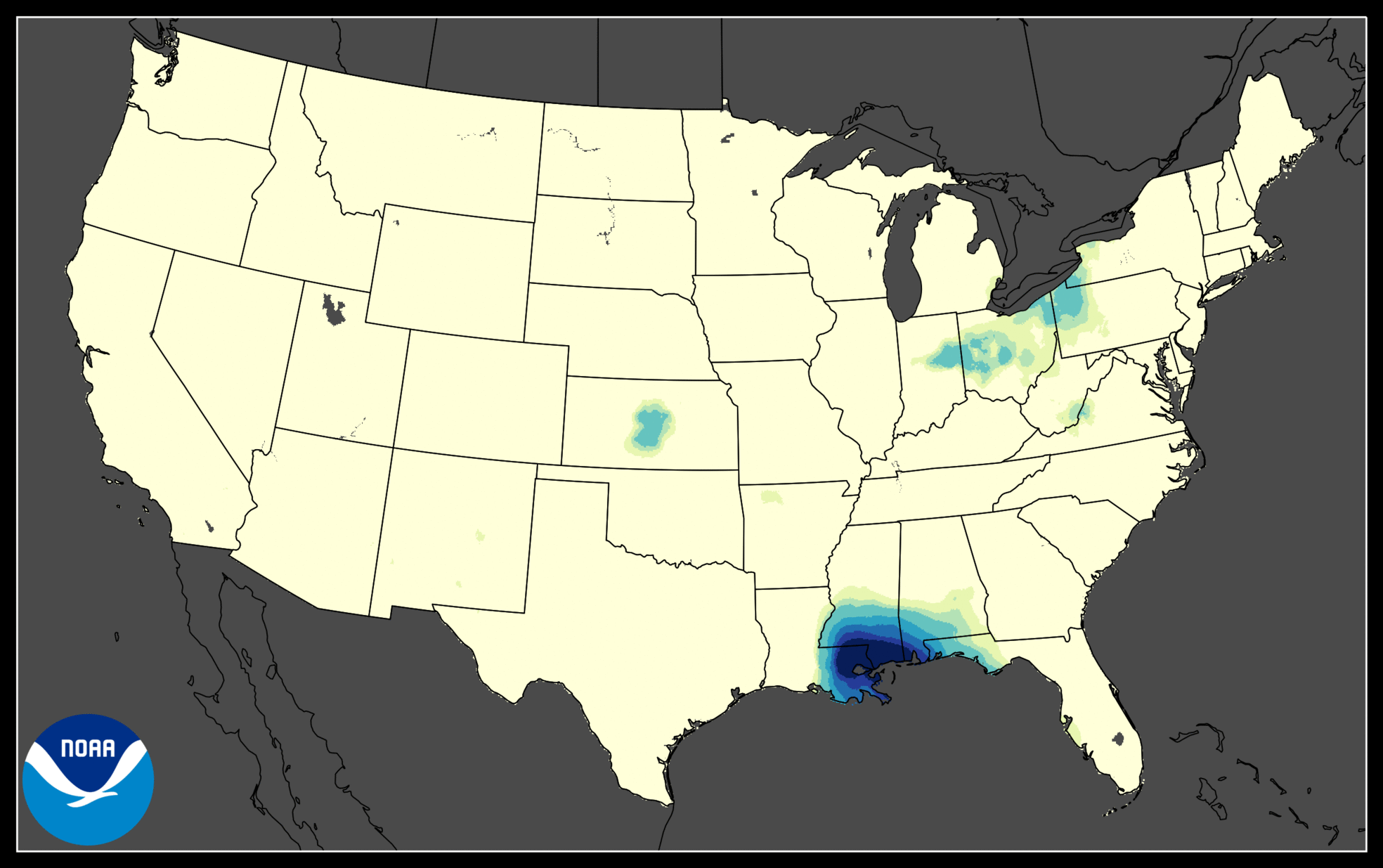
Precipitation accumulation and average temperature for the contiguous United States on September 2nd, 2021, when Hurricane Ida brought more than three inches of rain to areas in the Northeast.
Processing Methodology
The daily gridded fields are generated by interpolating morning and midnight observations from the Global Historical Climatology Network-daily (GHCNd) dataset (Menne et al. 2012) using thin-plate smoothing splines as implemented by the Australian National University (ANUSPLIN). Additional processing steps make it easier to identify grid points without precipitation and ensure internal consistency between daily maximum and minimum temperatures as well as consistency with NCEI's monthly nClimGrid product (Vose et al. 2014).
The temperature fields’ consistency with the monthly products also means that month-to-month inhomogeneities in the monthly mean have effectively been removed, because the monthly products are based on monthly-mean temperatures that have been adjusted using the pairwise homogenization algorithm (PHA) of Menne and Williams (2009). The details of these processing steps, as well as the rationale behind them, are provided in Durre et al. (2022a).
Notes
- The area averages are computed as means of the cosine-latitude-weighted values at grid points within the desired region. Census tract values are based on the tract boundaries associated with the 2020 census. For census tracts that have an area smaller than a grid box, the value at the nearest grid point is used.
- The auxiliary counts were obtained from the set of input observations used to construct the gridded fields. The count at each grid point represents the number of Tmax, Tmin, or Prcp observations located within 48.28 km (30 miles) of the coordinates of the grid point.
Update Frequency and Latency
Although preliminary nClimGrid-Daily fields and area averages often become available two to three days after the observation date, they may not be accurate enough for some applications because of latency issues. A significant amount of additional input data becomes available after the initial collection period. These data are incorporated into the preliminary estimates over the subsequent days and months, which maks them more accurate than the initial release.
Occasional data stream interruptions can result in a longer production period for nClimGrid-Daily. These delays affect estimates for days in the current month, which will not become fully consistent with the corresponding monthly products and daily estimates for previous months and years until approximately the fourth day of the following month.
Recommended Uses and Limitations
nClimGrid-Daily products were designed to support applications such as drought monitoring that require time series of spatially and/or temporally aggregated grid point values. Single-day values and individual points are inherently uncertain as a result of the spatial distribution of the underlying observations, differences in observation time between neighboring stations, and interpolation errors. Spatial and temporal averaging helps reduce the effect of these uncertainties, and time series of such aggregated values can be suitable for climatological applications.
Related Links
Contact Information
- Technical Questions: ncei.grids@noaa.gov
- Customer Support: ncei.info@noaa.gov
Related Publications
- Durre, I., A. Arguez, C. J. Schreck III, M. F. Squires, and R. S. Vose, 2022: Daily high-resolution temperature and precipitation fields for the Contiguous United States from 1951 to Present. Journal of Atmospheric and Oceanic Technology, doi:10.1175/JTECH-D-22-0024.1
- Durre, I., M. F. Squires, R. S. Vose, A. Arguez, W. S. Gross, J. R. Rennie, and C. J. Schreck, 2022b: NOAA's nClimGrid-Daily Version 1 – Daily gridded temperature and precipitation for the Contiguous United States since 1951. NOAA National Centers for Environmental Information, since 6 May 2022, doi:10.25921/c4gt-r169
- Menne, M.J., I. Durre, R.S. Vose, B.E. Gleason, and T.G. Houston, 2012: An overview of the Global Historical Climatology Network-Daily Database. Journal of Atmospheric and Oceanic Technology, 29, 897-910, doi:10.1175/JTECH-D-11-00103.1
- Menne, M. J., and C. N. Williams, 2009: Homogenization of temperature series via pairwise comparisons, J. Climate, 22, 1700–1717, doi:10.1175/2008JCLI2263.1
- Vose, R. S., Applequist, S., Squires, M., Durre, I., Menne, M. J., Williams, C. N., Jr., Fenimore, C., Gleason, K., & Arndt, D. (2014). Improved Historical Temperature and Precipitation Time Series for U.S. Climate Divisions, Journal of Applied Meteorology and Climatology, 53(5), 1232-1251. doi:10.1175/JAMC-D-13-0248.1