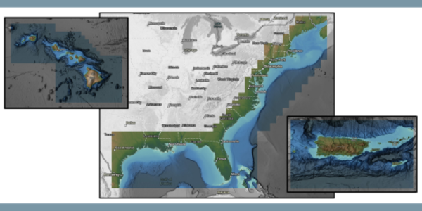
The NCEI Coastal Relief Models (CRMs) incorporate topographic and bathymetric data to create gridded elevation models that span onshore and offshore landscapes in the U.S coastal zone, including the continental U.S., Alaska, Hawaii, and Puerto Rico. The original CRMs were generated at a spatial resolution of 3 arc-seconds by merging digital elevation models (DEMs) from the U.S. Geological Survey (USGS) with soundings collected by the National Ocean Service and various academic institutions. Subsequent CRMs were generated at a refined spatial resolution of 1 arc-second by merging high-resolution DEMs, including NCEI’s suite of Continuously Updated DEMs (CUDEMs), as well as source data from other international, U.S. federal and state agencies (see User Guide for details).
Bathymetry Map Viewer
Use the Bathymetry Map Viewer to view and access NCEI's digital elevation, relief, and bathymetry data.
| Details | Year | Vertical Datum | Horizontal Datum | Spatial Resolution | Access Data |
|---|---|---|---|---|---|
| Vol. 1: Northeast Atlantic | 2023 | EGM 2008 | WGS84 | 1 arc-seconds | THREDDS |
| Vol. 2: Southeast Atlantic | 2023 | EGM 2008 | WGS84 | 1 arc-seconds | THREDDS |
| Vol. 3: Florida and East Gulf of America | 2023 | EGM 2008 | WGS84 | 1 arc-seconds | THREDDS |
| Vol. 4: Central Gulf of America | 2023 | EGM 2008 | WGS84 | 1 arc-seconds | THREDDS |
| Vol. 5: Western Gulf of America | 2023 | EGM 2008 | WGS84 | 1 arc-seconds | THREDDS |
| Vol. 6: Southern California | 2003 | Sea Level | NAD83 | 3 arc-seconds | THREDDS |
| Vol. 7: Central Pacific | 2024 | EGM 2008 | WGS84 | 1 arc-seconds | THREDDS |
| Vol. 8: Northwest Pacific | 2003 | Sea Level | NAD83 | 3 arc-seconds | THREDDS |
| Vol. 9: Puerto Rico | 2023 | Mean Sea Level | WGS84 | 1 arc-seconds | THREDDS |
| Vol. 10: Hawaii | 2023 | Mean Sea Level | WGS84 | 1 arc-seconds | THREDDS |
| Southern California Version 2 (1 arc-sec) | 2013 | Mean Sea Level | NAD83 | 1 arc-second | THREDDS |
| Southern California Version 2 (3 arc-sec) | 2013 | Mean Sea Level | NAD83 | 3 arc-seconds | THREDDS |
| Southern Alaska | 2009 | Sea Level | WGS84 | 24 arc-seconds | THREDDS |
| Name & Details | Year | Vertical Datum | Horizontal Datum | Spatial Resolution | Access Data |
|---|---|---|---|---|---|
| Vol. 1: Northeast Atlantic | 1998 | Sea Level | NAD83 | 3 arc-seconds | THREDDS |
| Vol. 2: Southeast Atlantic | 1998 | Sea Level | NAD83 | 3 arc-seconds | THREDDS |
| Vol. 3: Florida and East Gulf of America | 2001 | Sea Level | NAD83 | 3 arc-seconds | THREDDS |
| Vol. 4: Central Gulf of America | 2001 | Sea Level | NAD83 | 3 arc-seconds | THREDDS |
| Vol. 5: Western Gulf of America | 2001 | Sea Level | NAD83 | 3 arc-seconds | THREDDS |
| Vol. 9: Puerto Rico | 2004 | Sea Level | WGS84 | 3 arc-seconds | THREDDS |
| Vol. 10: Hawaii | 2004 | Sea Level | WGS84 | 3 arc-seconds | THREDDS |
Contact
Use Cases
Coastal DEMs offer researchers and decision makers a comprehensive look at the areas in their care by providing a foundational layer for localized Geographic and Land Information (GIS/LIS) mapping applications. The DEMs are an invaluable resource for federal, state, and local government agencies working to manage and respond to environmental pressures such as over development of beaches and wetlands, contamination of estuaries, increased economic costs associated with storm damage and flooding, dredging, oil and gas exploration/production, and overfishing.
Current Citations
Vol. 1–5, 9, 10 (2023)
NOAA National Centers for Environmental Information. (2023). Coastal Relief Models (CRMs) [Data set]. NOAA National Centers for Environmental Information. doi: 10.25921/5ZN5-KN44
Vol. 6: Southern California
National Geophysical Data Center, 2003. U.S. Coastal Relief Model - Southern California. National Geophysical Data Center, NOAA. doi:10.7289/V500001J [access date].
Vol. 7: Central Pacific
National Geophysical Data Center, 2003. U.S. Coastal Relief Model - Central Pacific. National Geophysical Data Center, NOAA. doi:10.7289/V50Z7152 [access date].
Vol. 8: Northwest Pacific
National Geophysical Data Center, 2003. U.S. Coastal Relief Model - Northwest Pacific. National Geophysical Data Center, NOAA. doi:10.7289/V5H12ZXJ [access date].
Southern California Version 2 (1 arc-sec)
National Geophysical Data Center, 2012. U.S. Coastal Relief Model - Southern California vers. 2. National Geophysical Data Center, NOAA. doi:10.7289/V5V985ZM [access date].
Southern California Version 2 (3 arc-sec)
National Geophysical Data Center, 2012. U.S. Coastal Relief Model - Southern California vers. 2. National Geophysical Data Center, NOAA. doi:10.7289/V5V985ZM [access date].
Southern Alaska
National Geophysical Data Center, 2009. Southern Alaska Coastal Relief Model. National Geophysical Data Center, NOAA. doi:10.7289/V58G8HMQ [access date].
Volume 1: Northeast Atlantic
National Geophysical Data Center, 1999. U.S. Coastal Relief Model - Northeast Atlantic. National Geophysical Data Center, NOAA. doi:10.7289/V5MS3QNZ [access date].
Volume 2: Southeast Atlantic
National Geophysical Data Center, 1999. U.S. Coastal Relief Model - Southeast Atlantic. National Geophysical Data Center, NOAA. doi:10.7289/V53R0QR5 [access date].
Volume 3: Florida
National Geophysical Data Center, 2001. U.S. Coastal Relief Model - Florida and East Gulf of America. National Geophysical Data Center, NOAA. doi:10.7289/V5W66HPP [access date].
Vol. 4: Central Gulf of America
National Geophysical Data Center, 2001. U.S. Coastal Relief Model - Central Gulf of America. National Geophysical Data Center, NOAA. doi:10.7289/V54Q7RW0 [access date].
Vol. 5: Western Gulf of America
National Geophysical Data Center, 2001. U.S. Coastal Relief Model - Western Gulf of America. National Geophysical Data Center, NOAA. doi:10.7289/V5QJ7F79 [access date].
Vol. 9: Puerto Rico
National Geophysical Data Center, 2005. U.S. Coastal Relief Model - Puerto Rico. National Geophysical Data Center, NOAA. doi:10.7289/V57H1GGW [access date].
Vol. 10: Hawaii
National Geophysical Data Center, 2005. U.S. Coastal Relief Model - Hawaii. National Geophysical Data Center, NOAA. doi:10.7289/V5RF5RZZ [access date].
Frequently Asked Questions
What is the horizontal datum of the model?
The horizontal datum of the U.S. CRM is WGS84 geographic or for the older CRM volumes, NAD83 geographic. All source elevation data used in building the CRM were transformed to these datum prior to CRM development.
What is the vertical datum of the model?
The vertical datum of the U.S. CRM is either EGM2008 or Mean Sea Level (sea level). Newer CRMs were generated at a refined spatial resolution of 1 arc-second by merging high-resolution DEMs, including NCEI’s suite of Continuously Updated DEMs (CUDEMs), as well as source data from other international, U.S. federal and state agencies (see User Guide for details).
For older, pre-2013 CRMs, source elevation data were not converted to a common vertical datum due to the large cell size of the CRM (3 arc-second; ~90 meters). This means that the vertical uncertainty of CRM elevations (greater than one meter) exceeds the differences between vertical datums (usually less than a meter). Source bathymetric data retained their original vertical datum of either mean lower low water (MLLW) or mean low water (MLW), while source topographic data remained in either NAVD 88 or NGVD 29 prior to CRM development.
What are the vertical units of the model?
Elevations of the CRM are in meters.
Are there any restrictions on using this model?
Just two:
- The U.S. CRM cannot be used for navigation.
- Products derived primarily from NCEI data are not subject to copyright protection in the United States (see copyright). Use the citations tab to acknowledge NCEI as source.
How can I extract a specific area of the CRM?
You can extract a part of the CRM by using the 'Grid Extract' tool that can be found on the various CRM web pages.
Are there metadata records for the CRM?
Are there plans to update the CRM volumes?
Yes. As resources allow, all 10 volumes of the U.S. CRM will be updated. In 2023, volumes 1 through 5 for the Eastern and Gulf Coasts of the U.S. and volumes 9 and 10 for Puerto Rico and Hawaii were updated.


