
The Integrated Global Radiosonde Archive (IGRA) consists of radiosonde and pilot balloon observations from more than 2,800 globally distributed stations. The earliest data date back to 1905, and recent data become available in near real time from about 800 stations worldwide. Observations are available at standard and variable pressure levels, fixed and variable-height wind levels, and the surface and tropopause. Variables include pressure, temperature, geopotential height, relative humidity, dew point depression, wind direction and speed, and elapsed time since launch.

Current Version: IGRA 2.2
Status Updates
IGRA version 2.2 includes two additional real-time sources that update IGRA records for more than 100 stations that started transmitting their radiosonde reports in the Binary Universal Form for Representing meteorological data (BUFR). These reports could no longer be updated by the IGRA v2.0 system. In v2.2, the two new input data streams, which contain radiosonde reports received in BUFR, are used to fill in the resulting gaps in IGRA. For additional information on how the sources are used, see the updated documentation below.
Documentation
Please review the following files before downloading data:
- IGRA 2 Product Description
- Readme: An explanation of the available file types and locations.
- Station Inventory: This inventory contains the name, country, most recent location, network affiliation, and period of record of each station. The station identifiers are used to identify observing sites within the data files and are also part of the names of files containing sounding data and sounding-derived parameters.
- Country Codes: A list of FIPS 10-4 country codes for countries, dependencies, areas of special sovereignty, and their principal administrative divisions. These codes are the first two letters of the IGRA station identifiers
- Data and Metadata Formats: Folder containing additional documents, each of which describes the format of a specific type of data or metadata available within IGRA
Data
All IGRA-related information is provided in plain-text files. The data in each file are deliberately organized so that both humans and computer programs can easily read and process the information. Alternate formats are not currently available.
Files are available via two commonly-used protocols: HTTPS and legacy FTP. Use the HTTPS links for bulk downloads or to browse folders and manually download individual files. The FTP addresses are best used for bulk downloads from Linux servers and similar consoles and are not supported by all browsers.
There are three types of IGRA data files:
Sounding Data
Individual soundings, organized into one file per station, are provided for the most recent one to three years and for the full period of record.
- HTTPS: Recent Sounding Data
- HTTPS: All Sounding Data
- FTP: All sounding data are available at ftp.ncei.noaa.gov/pub/data/igra/ under data-y2d/ and data-por/
- Sounding Data Format
Monthly Means
Monthly means are organized into one file per variable and time of day (0000 and 1200 Coordinated Universal Time) and are available for the most recent complete month and the full period of record.
- HTTPS: Last Month's Means
- HTTPS: All Monthly Means
- FTP: Monthly Means are available at ftp.ncei.noaa.gov/pub/data/igra under monthly-upd/ and monthly-por/
- Monthly Means Format
Derived Parameters
Assorted humidity and stability parameters, derived from the IGRA soundings, are organized into one period-of-record file per station.
- HTTPS: Derived Parameters
- FTP: Derived Parameters are available at ftp.ncei.noaa.gov/pub/data/igra/ under derived-por/
- Parameter File Format
Components
IGRA consists of three components:
- Individual soundings, organized into one file per station
- Monthly means, organized into one file per variable and time of day (0000 and 1200 Coordinated Universal Time)
- Sounding-derived parameters, organized into one file per station
NCEI also provides access to IGRA station metadata that can be helpful for interpreting data. They include current station names and locations as well as information on changes in station location, instrumentation, and observing practices over time, to the extent that they are available.
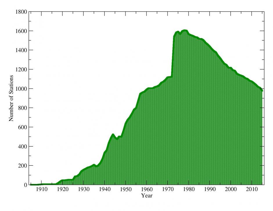
The IGRA period of record varies for each station and variable. Approximately 800 of the more than 2,800 IGRA stations are currently reporting data. Vertical extent as well as temporal and vertical resolution also vary among stations and over time.
Recommended Uses and Limitations
IGRA can be used as input to air pollution models, for studies of the detailed vertical structure of the troposphere and lower stratosphere, for assessing the atmospheric conditions during a particular meteorological event, and for many other analyses and operational applications. NCEI scientists have applied a comprehensive set of quality control procedures to the data to remove gross errors. However, the data may still include jumps and other discontinuities caused by changes in instrumentation, observing practice, or station location. Users studying long-term trends may prefer to use the NOAA Radiosonde Atmospheric Temperature Products for Assessing Climate (RATPAC) or one of the available non-NOAA IGRA-derived, homogeneity-adjusted radiosonde datasets.
Contact Information
Technical Questions
Customer Support
Raw BUFR Data
NCEI archives three data streams of upper air observationsI. They are available in their original form for users interested in the high vertical resolution or additional metadata that can be available in profiles transmitted in this format.
NWSTG Global Upper Air BUFR data
These data originate from stations around the globe with a timeframe of 2017–present, and are updated daily. They contain soundings collected from the Global Telecommunication System by the U.S. National Weather Service’s Telecommunications Gateway (NWSTG). This is one of the two BUFR data sources that is used to fill in gaps in the traditional GTS record beginning with IGRA v2.2.
Download Raw NWSTG Global Upper Air BUFR Data
ECMWF Global Upper Air BUFR data
These data originate from stations and ships around the globe, cover the years 2014 to present, and are updated at NCEI once a month. They contain radiosonde reports collected from the Global Telecommunication System by the European Centre for Medium-Range Weather Forecasts (ECMWF). This is one of the two BUFR data sources that is used to fill in gaps in the traditional GTS record beginning with IGRA v2.2.
Download Raw ECMWF Global Upper Air BUFR Data
NWS-Managed Upper Air Observations in BUFR for the U.S., Caribbean, and Pacific Islands
These data originate from stations managed by the National Weather Service (NWS), including 92 in North America and the Pacific Islands, as well as 10 in the Caribbean, and cover the years 2005 to present. They contain radiosonde and pilot balloon reports collected by the NWS and are transmitted directly to NCEI in near-real time from the majority of the sites (~80) and once a month from the remaining locations. These data are currently not included in IGRA since they do not provide significant information that is not included in the other IGRA data sources.
Download Raw NWS-Managed Upper Air BUFR Data
RATPAC
The Radiosonde Atmospheric Temperature Products for Assessing Climate (RATPAC) are a collection of radiosonde-based temperature anomaly time series for 1958–present. These products address the temporal inhomogeneities created by changes to instruments and observing practices, and reduce them as much as possible. Post-1995 RATPAC data are derived from IGRA.
Additional Information
IGRA Station history information containing Information about changes in station location, instrumentation, and observing practices: For details, see the IGRA readme file.
Related Publications
- Durre, I., Yin, X., Vose, R. S., Applequist, S., & Arnfield, J., 2018: Enhancing the Data Coverage in the Integrated Global Radiosonde Archive, Journal of Atmospheric and Oceanic Technology, 35(9), 1753-1770. DOI:10.1175/JTECH-D-17-0223.1 . [Overview of enhancements and data additions that resulted in IGRA version 2.0.]
- Durre, I., R. S. Vose, and D. B. Wuertz, 2006: Overview of the Integrated Global Radiosonde Archive. Journal of Climate, 19, 53-68. [Overview of IGRA version 1.] DOI:10.1175/JCLI3594.1
- Durre, I., R. S. Vose, and D. B. Wuertz, 2008: Robust automated quality assurance of radiosonde temperatures. Journal of Applied Meteorology and Climatology, 47, 2081-2095. DOI:10.1175/2008JAMC1809.1 . [This paper describes the temperature quality control procedures that were developed for IGRA 1 and continue to be applied to newer versions of IGRA.]
- Durre, I., and X. Yin, 2008: Enhanced radiosonde data for studies of vertical structure. Bulletin of the American Meteorological Society, 89, 1257-1262. [Paper describing the original version of the sounding-derived parameters. The methodology described in this paper also applies to IGRA V2.]
- Durre, I., and X. Yin, 2011: Enhancements of the dataset of sounding parameters derived from the Integrated Global Radiosonde Archive. 23rd Conference on Climate Variability and Change, Seattle, WA, 25 January 2011. [Available online at https://ams.confex.com/ams/91Annual/webprogram/Paper179437.html.] | PDF
- Durre, I., C. N. Williams, Jr., X. Yin, and R. S. Vose, 2009: Radiosonde-based trends in precipitable water over the Northern Hemisphere: An update. Journal of Geophysical Research, 114, D05112,
DOI:10.1029/2008JD010989. [Analysis of homogeneity-adjusted time series of monthly-mean surface to 500-hPa precipitable water derived from IGRA.] - Ingleby, B., et al, 2016: Progress toward high-resolution, real-time radiosonde reports. Bulletin of the American Meteorological Society, 2149-2161, DOI:10.1175/BAMS-D-15-00169.1. [Background on radiosonde data in BUFR format.]
