NOAA scientists study the influence of several factors, including ocean heat content

The Gulf Stream (GS) in the North Atlantic Ocean—an ocean flow nearly four times more powerful than the Amazon River—has been the subject of many ocean studies for decades. A recent research study from NOAA scientists focused on the variability of the stream’s pathway and its amazing long-term resilience.
The Gulf Stream is a warm water current originating in the Gulf of Mexico where it moves poleward an average speed of 4 mph along the Atlantic seaboard from Florida to North Carolina. It then heads east-northeast eventually becoming the North Atlantic Current, which is responsible for keeping the Northeast Atlantic and Nordic Seas relatively warm. Scientists from the NCEI Regional Climatology Team set out to understand two important aspects of the GS:
- How significantly does the GS path’s position vary on 10-year (decadal) timescales?
- Can the decadal changes in the GS path be caused by or linked to long-term ocean warming or cooling?
For answers, they compared the variability, or displacement, of the GS to changes in North Atlantic ocean heat content—a major factor in understanding long-term ocean climate change. The research explored other factors to help understand why and how far the GS has migrated by periods of 10 years or longer.
“Some of the most advanced high-resolution ocean models still struggle to resolve the GS structure and dynamics,” the researchers stated while emphasizing the role of addressing the GS long-term variability using point-of-origin (in situ) oceanographic observations.
A Robust Gulf Stream
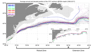
The study, published in Nature Scientific Reports, specifically examines the position of the GS marked by the position of the Gulf Stream North Wall (GSNW; defined as the 15°C isotherm at 200 meters depth).
Using averaged seawater temperatures from the World Ocean Database 2018, the pathway of the GSNW was mapped over five decades, from 1965 to 2017. The variation between decades, measured by the standard deviations of latitudinal position of the GSNW relative to its multi-year averaged position, remained relatively small for much of the GS path.
However, the pathway of the current did vary over time, and the current path’s envelope widened, particularly in a section that the researchers referred to as the “extension zone,” the part of the stream running between 50°W–40°W (just east of the Grand Banks). In contrast, the path within the “robust zone,” a longer section hugging the East Coast shelfbreak, a zone where the shelf becomes the oceanic slope, remained remarkably cohesive.
According to the authors from NCEI and Earth System Science Interdisciplinary Center at the University of Maryland, “Despite the GS being exposed to multiple external forces and experiencing internal instabilities and continuous interactions with surrounding water masses, the robustness of the GS pathway between 75°W and 50°W is nothing less than spectacular.”
Gulf Stream Dynamics and Drift
Relative to long-term warming already documented by many studies of the North Atlantic Ocean, the research supported the broader scientific consensus that the path of the Gulf Stream wasn’t deviating significantly but was resilient to many factors. Some of these factors that the authors investigated were: wind stress variability, and different modes of natural climate variability such as the North Atlantic Oscillation (NAO), Atlantic Multidecadal Oscillation (AMO), and El Niño–Southern Oscillation (ENSO).
“Many diverse factors influence the GS dynamics. It is therefore unlikely that the GSNW would correlate significantly with all or most of them over the long run,” the authors wrote.
One of the most important results in the study revealed a strong relationship between the northward drift of the GS, which has occurred slowly over time, and upper ocean warming measured by an increase in ocean heat content. The connection between the northward drift of the GS path and increasing ocean heat content may be, at least partially, explained by the warming of water to the southeast of the GS path.
Additionally, significant correlations were found between the Gulf Stream path’s variability as well as the AMO—naturally occurring ocean warming and cooling cycles. Although the study covered the past five decades, many questions still remain, making it critical that long-term ocean monitoring of the North Atlantic continue.


