Use the form below to select from a collection of monthly summaries recapping climate-related occurrences on both a global and national scale.
National Climate ReportSeptember 2017
National Overview:
- Climate Highlights — September
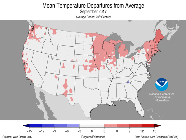 September Average Temperature Departures |
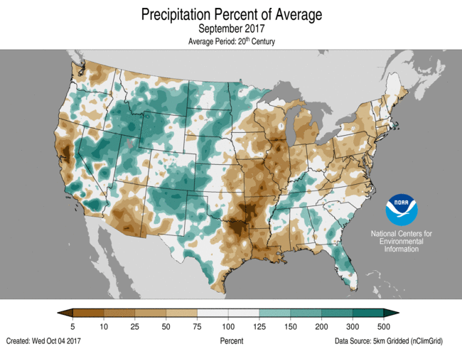 September Percent of Average Precipitation |
Temperature
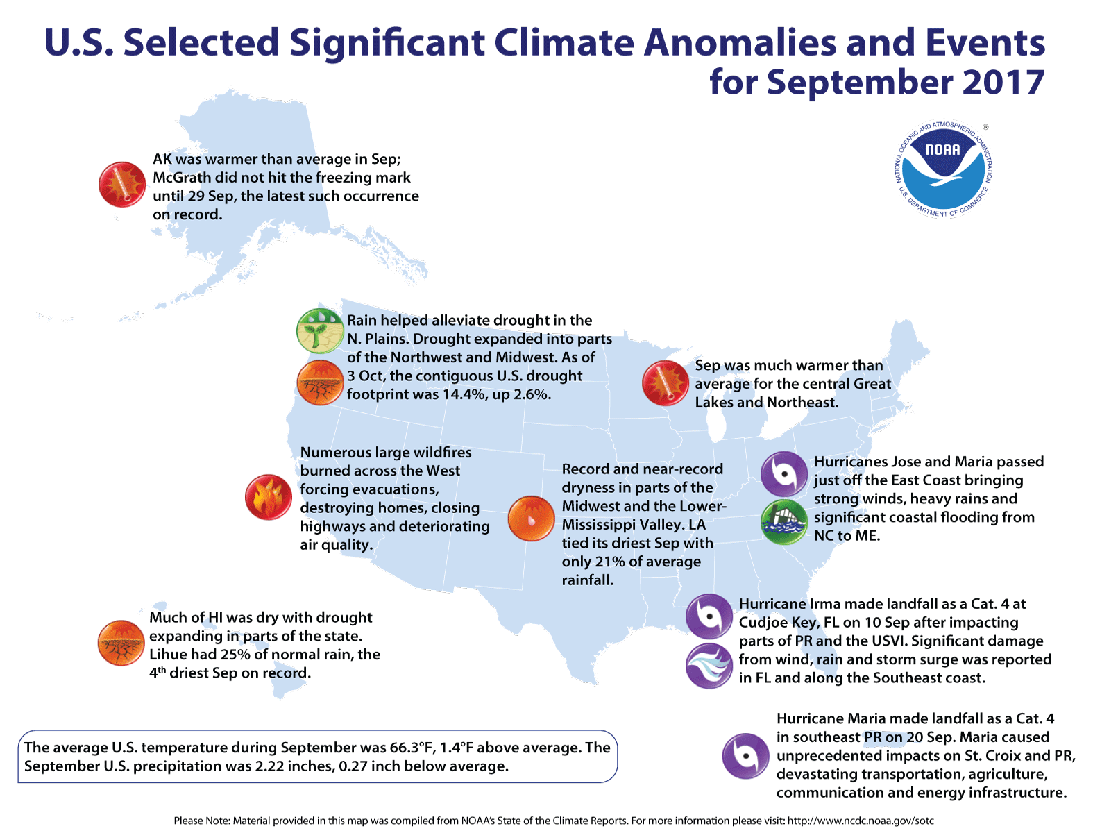
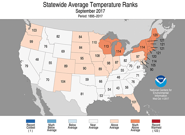
- The September nationally averaged temperature was 66.3°F, 1.4°F above the 20th century average, and ranked among the warmest third of the historical record.
- The temperature pattern across the contiguous U.S. shifted dramatically in mid-September. Early in the month, record and near-record warmth spanned the West with below-average conditions across the East. For the last two weeks of September, record or near-record warmth was observed in the East with below-average temperatures in the West. This pattern caused many states to have near- to above-average temperatures for September with much-above-average temperatures in the central Great Lakes and Northeast.
- During September, the Alaska statewide average temperature was 42.8°F, 2.2°F above average. North-central and southeastern Alaska were much warmer than average. The temperature in McGrath did not drop below the freezing mark until September 29, the latest such occurrence on record. The previous record was September 25, set just last year.
- The contiguous U.S. average maximum (daytime) temperature during September was 78.8°F, 1.0F above the 20th century average, the 41th warmest on record but coolest since 2014. Above-average maximum temperatures were observed across the central Plains to Northeast. Below-average maximum temperatures were observed in the Great Basin and parts of the Southeast.
- The contiguous U.S. average minimum (nighttime) temperature during September was 53.8°F, 1.9°F above the 20th century average, the 16th warmest on record. Above-average minimum temperatures spanned the West, Northern and Central Plains, Midwest, and Northeast.
- During September there were 7,567 record warm daily high (4,147) and low (3,420) temperature records, which was more than twice the 3,459 record cold daily high (2,250) and low (1,209) temperature records.
- Based on NOAA's Residential Energy Demand Temperature Index (REDTI), the contiguous U.S. temperature-related energy demand during September was 30 percent below average and ranked near the middle value in the 123-year period of record.
Precipitation
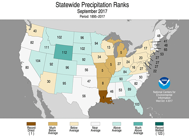
- For September, the national precipitation total was 2.22 inches, 0.27 inch below average, and ranked among the driest third of the historical record.
- Below-average precipitation was observed for the mid- and lower-Mississippi Valley stretching into the Great Lakes and Northeast where five states were much drier than average. After having its second wettest August, Louisiana tied its driest September on record. The Louisiana statewide average precipitation total was 0.87 inch, 3.25 inches below average, tying 1953 as the driest on record.
- Above-average precipitation was observed for a large area extending from the Great Basin, through the Rocky Mountains and into the Northern Plains. Parts of the Southeast were also wetter than average. Wyoming was the only much wetter than average state. Many mountain locations in the West received their first snow of the season.
- According to the October 3 U.S. Drought Monitor report, 14.4 percent of the contiguous U.S. was in drought, up nearly 2.6 percent compared to the end of August. Drought improved across parts of the Northwest and Northern to Central Plains. Drought conditions expanded and intensified in parts of the Midwest and Southern Plains and other parts of the Northwest. Outside of the contiguous U.S., drought conditions were alleviated in southern Alaska and southern Puerto Rico but expanded in parts of Hawaii.
Extremes
- September was an extremely active hurricane month for the North Atlantic Basin with five hurricanes — four of which were major hurricanes. One measure of tropical cyclone activity—the Accumulated Cyclone Energy (ACE) index, which takes into account the combined strength and duration of tropical cyclones — was record high in the North Atlantic during September. Hurricane Irma devastated parts of Puerto Rico, the U.S. Virgin Islands and Florida. Then Hurricane Maria delivered a second punch, causing unprecedented impacts on Puerto Rico and the U.S. Virgin Islands.
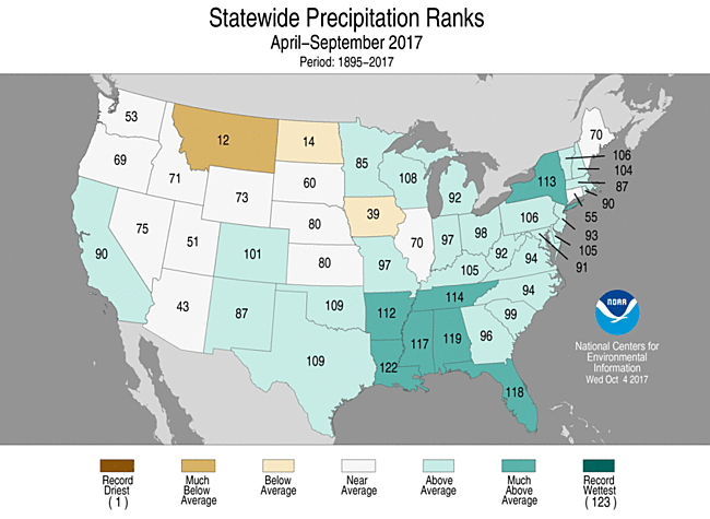
- Climate Highlights — warm season (April-September)
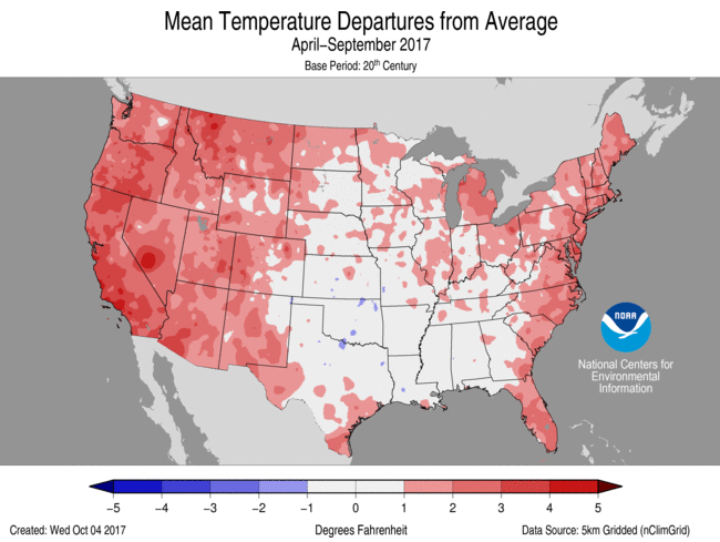 Apr-Sep Average Temperature Departures |
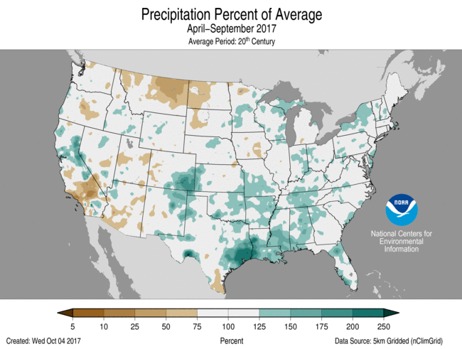 Apr-Sep Percent of Average Precipitation |
Temperature
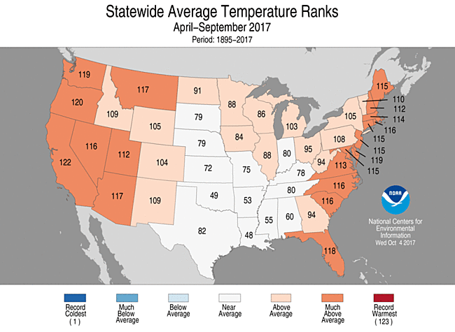
- The warm season U.S. average temperature was the 11th warmest on record at 66.4°F, 1.4°F above average.
- Above-average temperatures for the warm season were observed in the West, Great Lakes, and along the East Coast, where 19 states were much above-average. The Great Plains and Southeast had near-average warm season temperatures.
- The contiguous U.S. average maximum (daytime) temperature during April-September was 79.0°F, 1.1°F above the 20th century average, the 25th warmest on record. Above-average maximum temperatures were observed for the West Coast and East Coast. Below-average maximum temperatures stretched from the southern Plains to central Gulf Coast.
- The contiguous U.S. average minimum (nighttime) temperature during April-September was 53.9°F, 1.7°F above the 20th century average, ranking as the sixth warmest on record. Above-average minimum temperatures spanned the West and the East with near-average conditions for parts of the Great Plains. California and Oregon each had a record warm minimum temperature for the warm season.
Precipitation
- The warm season U.S. precipitation total was 18.32, 2.08 inches above average. This was the ninth wettest April-September on record.
- Above-average precipitation fell across most of the West, Southern Plains, Southeast, and Great Lakes to Northeast. Below-average precipitation fell in the Northern Rockies, Northern Plains, and parts of the Midwest. No state was record wet or dry for the six-month period.
Extremes
- The USCEI for the warm season was the 17th highest value on record at 80 percent above average. On the national scale, extremes in warm maximum and minimum temperatures, one-day precipitation totals and landfalling tropical cyclones contributed to the elevated USCEI.
- Climate Highlights — year-to-date (January-September)
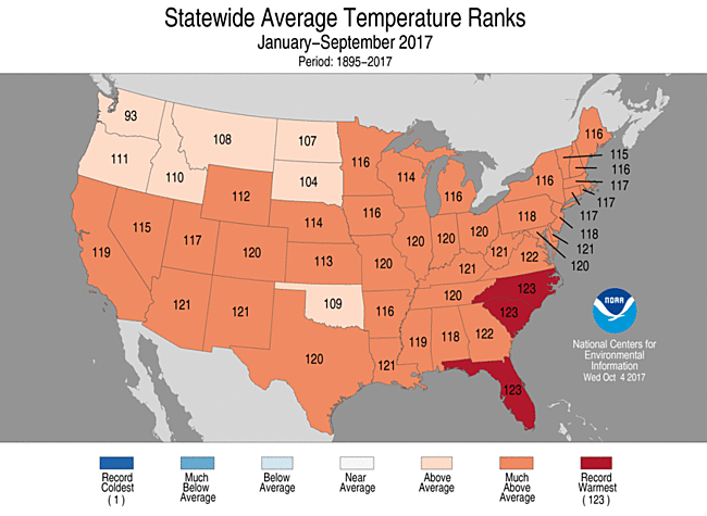
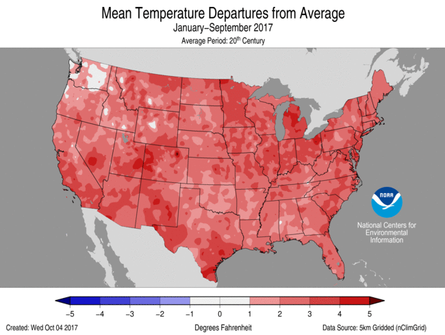 Jan-Sep Average Temperature Departures |
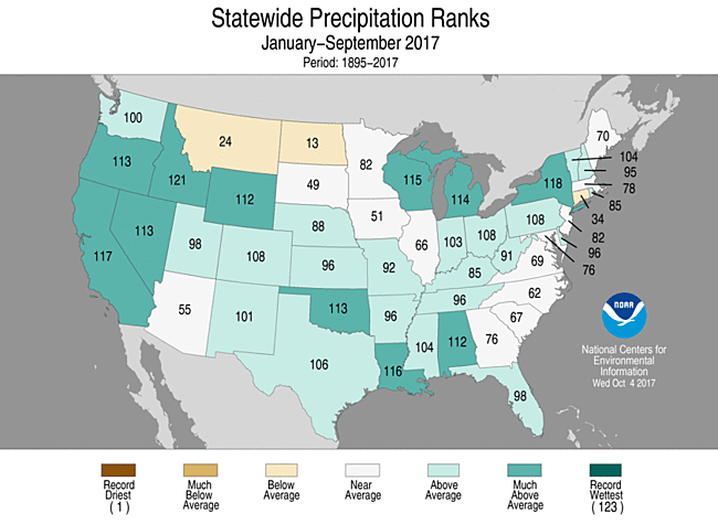
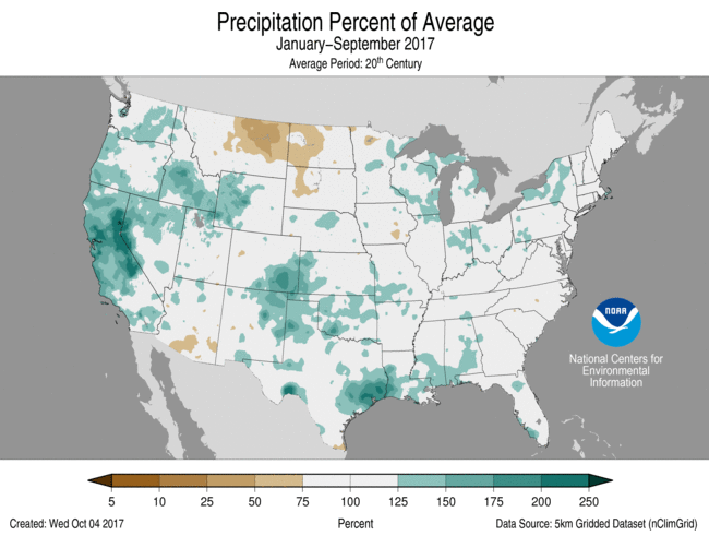 Jan-Sep Percent of Average Precipitation |
Temperature
- The year-to-date U.S. average temperature was the third warmest on record at 57.7°F, 2.7°F above average. Only January-September of 2012 and 2016 were warmer.
- Every state across the contiguous U.S. had an above-average temperature for the first nine months of the year. Forty-one states, stretching from coast to coast, had much-above-average temperatures for January-September. Three states in the Southeast—Florida, North Carolina and South Carolina—were record warm.
- The contiguous U.S. average maximum (daytime) temperature during January-September was 69.6°F, 2.3°F above the 20th century average, the sixth warmest on record. Above-average maximum temperatures spanned the nation during the first nine months of the year.
- The contiguous U.S. average minimum (nighttime) temperature during January-September was 45.8°F, 3.0°F above the 20th century average, ranking as the third warmest on record. Above-average minimum temperatures spanned the nation with every state having above-average conditions. Seven states across the Southwest and Southeast had record warm January-September minimum temperatures.
Precipitation
- The year-to-date U.S. precipitation total was 26.36, 3.16 inches above average. This was the wettest January-September on record, surpassing the previous record set in 1979.
- Most locations had wetter than average conditions during January-September. Much-above-average precipitation was observed across the West, and parts of the Southern Plains, central Gulf Coast, and Great Lakes. Eleven states were much wetter than average, while no state was record wet. Conversely, below-average precipitation was observed across the Northern Rockies and Northern Plains. No state was record dry.
Extremes
- The USCEI for the year-to-date was the third highest value on record at over one and a half times the average. On the national scale, extremes in warm maximum and minimum temperatures, one-day precipitation totals and landfalling tropical cyclones contributed to the elevated USCEI. The USCEI is an index that tracks extremes (falling in the upper or lower 10 percent of the record) in temperature, precipitation, drought and landfalling tropical cyclones across the contiguous U.S.
- Regionally, the CEI was much-above-average in the Ohio Valley, Southeast, and Southwest. In each, extremes in warm maximum and minimum temperatures were near-record high. In the Southwest, one-day precipitation totals were record high.
**A comparison of the national temperature departure from average as calculated by NCDC's operational dataset (nClimDiv), the U.S. Historical Climatology Network (USHCN), and the U.S. Climate Reference Network (USCRN) is available on our National Temperature Index page.**
Regional Highlights:
These regional summaries were provided by the six Regional Climate Centers and reflect conditions in their respective regions. These six regions differ spatially from the nine climatic regions of the National Centers for Environmental Information.
- Northeast Region: (Information provided by the Northeast Regional Climate Center)
- Despite a cool start to the month, temperatures rebounded and September wrapped up on the warm side of normal. The Northeast's average temperature was 63.7 degrees F (17.6 degrees C), 3.0 degrees F (1.7 degrees C) above normal, making it the region's eighth warmest September since 1895. For the first time in five months, the monthly average temperature for all twelve states was above normal. Departures ranged from 0.7 degrees F (0.4 degrees C) in West Virginia to 5.5 degrees F (3.1 degrees C) above normal in Maine. Nine states ranked this September among their top 20 warmest on record: Massachusetts, New Hampshire, Rhode Island, and Vermont, third warmest; Connecticut and Maine, fourth warmest; New Jersey and New York, 10th warmest; Delaware, 19th warmest.
- September was a dry month for the Northeast. The region received 2.40 inches (60.96 mm) of precipitation, 61 percent of normal, making it the 19th driest September since recordkeeping began. This was the first month since November 2016 that all twelve states were drier than normal, with precipitation ranging from 47 percent of normal in Maryland to 85 percent of normal in Massachusetts. Three states ranked this September among their top 20 driest on record: West Virginia, 16th driest; New York, 17th driest; and Pennsylvania, 20th driest.
- The U.S. Drought Monitor released on September 7 showed parts of northern and eastern Maine, totaling 5 percent of the Northeast, was in a moderate drought. Abnormal dryness covered 8 percent of the region, including parts of Maine, southeastern New Hampshire, southeastern Massachusetts, southern Rhode Island, southern Connecticut, and New York's Long Island. While moderate drought and abnormal dryness eased somewhat in Maine, dry conditions lingered in the other areas. In addition, abnormal dryness expanded in southern New England and was introduced in parts of Vermont, New York, Pennsylvania, and West Virginia. The U.S. Drought Monitor released on September 28 showed 4 percent of the Northeast was in a moderate drought and 18 percent of the region was abnormally dry.
- Severe weather moved through the region from September 4 to 6. Winds of up to 80 mph (36 m/s) downed trees, wires, and poles. Up to 4 inches (102 mm) of rain caused flash flooding in some areas, and golf-ball-sized hail was also reported. Between September 19 and 23, Tropical Storm Jose caused rough seas, high waves, and rip currents from Maryland to Maine. Portions of the region also experienced coastal flooding and beach erosion. The storm stalled off the Cape Cod (Massachusetts) coast, bringing tropical storm-force winds and rain to parts of New England. The greatest rain total was 6.41 inches (162.81 mm) in Nantucket, Massachusetts. The first half of September featured below-normal temperatures for much of the Northeast, but a big warm up occurred starting on September 23. Unusually warm temperatures of up to 94 degrees F (34 degrees C) set numerous records across the region. These temperatures were the warmest temperatures all year for several sites, including Binghamton and Rochester in New York. For some sites, like Caribou, Maine, these temperatures were the warmest temperatures they had experienced so late in the calendar year. Nine major climate sites experienced a heat wave (three or more consecutive days of at least 90 degrees F [32 degrees C]) sometime between September 23 and 27. For some of these sites, such as Burlington, Vermont, and Albany, New York, it was the latest heat wave in a calendar year. In fact, it was Albany's first ever heat wave recorded in astronomical autumn.
- For more information, please go to the Northeast Regional Climate Center Home Page.
- Midwest Region: (Information provided by the Midwest Regional Climate Center)
- September precipitation in the Midwest varied from more than 200 percent of normal to less than 10 percent of normal. The wettest areas were in northwestern Minnesota and Kentucky with much of the area between being well below normal for September. A wide swath from Missouri to Lower Michigan had precipitation totals below 50 percent of normal with many areas below 25 percent and some locations with less than 10 percent of normal. Statewide precipitation totals ranged from slightly over normal in Kentucky and Minnesota to less than 25 percent of normal in Missouri and Illinois. Heavy rainfall in Kentucky was largely due to the remnants of Hurricane Harvey passing over the state in the first couple days of the month.
- September temperatures were below normal across the Midwest for the first several days of the month. After a few days with warmth in the northwest and continued cooler weather in the southeast, very warm conditions dominated for two weeks until seasonal temperatures returned for the last couple days of September. Record low daily temperatures numbered nearly 500 mostly in the first 10 days of September. Record high daily temperatures numbered more than 2300 during the month with most occurring in the latter half of the month. The records included a string of five days (20th to 24th) in Chicago with highs over 90 degrees F (32 C) with each day being a record. Statewide temperatures ranged from near normal in Kentucky to more than 3.0 degrees F (1.7 C) above normal for each of Iowa, Minnesota, Wisconsin, and Michigan.
- Severe weather was reported on 13 days in September. All nine Midwest states had at least a handful of reports but the majority of the reports came from Minnesota. Tornadoes were reported in Ohio (EF-2 with two injuries) on the 4th and in Minnesota on the 19th. Hail reports were most numerous in Minnesota on the 14th and wind reports were most numerous on the 19th, also in Minnesota.
- Corn and soybean harvest began across much of the Midwest in September. As has been the case for most of the growing season, impacts were localized making it hard to generalize across the region. Corn harvest was running behind in Iowa and Illinois in particular. Soybean harvest was well behind average in Minnesota while running ahead in Illinois and Michigan. The soybean harvest in Indiana and Ohio was hampered, despite good field access, by the dryness that led to combine fires and concerns about splitting or shattering of the beans.
- Drought expanded from just under 7.5 percent of the Midwest on August 29th to just under 12 percent of the region on October 3rd according to the US Drought Monitor. The portion of the region noted as abnormally dry or worse increased from about 19 percent to 38 percent in the same time. The small area of extreme drought in southern Iowa shrank slightly during the month.
- For further details on the weather and climate events in the Midwest, see the weekly and monthly reports at the Midwest Climate Watch page.
- Southeast Region: (Information provided by the Southeast Regional Climate Center)
- Temperatures were near average across much of the Southeast region during September. Over 85 percent of the 182 long-term (i.e., period of record equaling or exceeding 50 years) stations within the region observed September mean temperatures that were ranked outside their ten warmest or coolest values on record. However, well-above-average temperatures (driven primarily by extremely warm minimum temperatures) continued across portions of central and southern Florida, as well as Puerto Rico. Several long-term stations in Florida observed or tied their warmest or second warmest September mean temperature on record, including Miami (1896-2017; warmest on record), Melbourne (1937-2017; tied for warmest), Tampa (1890-2017; second warmest), West Palm Beach (1888-2017; second warmest), and Fort Lauderdale (1913-2017; tied for second warmest). With warmer-than-normal sea surface temperatures measured offshore, a few stations along the coastline of southeastern Florida and northern Puerto Rico observed their highest count of September days with a minimum temperature of at least 75 degrees F (23.9 degrees C), such as West Palm Beach, FL (30 days) and Stuart, FL (1936-2017; 28 days), or 80 degrees F (26.7 degrees C), such as Miami, FL (14 days) and San Juan, PR (1899-2017; 14 days). On the 8th, Miami tied its highest minimum temperature for any month on record, at 84 degrees F (28.9 degrees C). Across the Southeast, the warmest weather of the month occurred from the 20th through the 22nd and the 26th through the 28th, as unseasonably warm and humid air masses stagnated over the region. Daytime maximum temperatures ranged from 85 to more than 95 degrees F (29.4 to more than 35 degrees C) across much of the region, while nighttime minimum temperatures remained above 60 degrees F (15.6 degrees C). In contrast, the coolest weather of the month occurred from the 7th through the 9th, as a continental high pressure system ushered in unusually cool air from the northwest. Daily minimum temperatures fell below 60 degrees F across much of the region north of Florida, with elevated portions of western North Carolina and Virginia reaching the middle 30s F to the middle 40s F (1.7 to 7.2 degrees C). From the 10th through the 13th, cloud cover and rainfall associated with Hurricane Irma produced record low daily maximum temperatures across every state in the region. On the 11th, several long-term stations observed or tied their lowest maximum temperature on record for September, including Sylacauga 4 NE, AL (1955-2017; 59 degrees F, 15 degrees C), Greenville, AL (1927-2017; 62 degrees F, 16.7 degrees C), Chipley, FL (1939-2017; 65 degrees F, 18.3 degrees C), and Tallahassee, FL (1892-2017; 65 degrees F).
- Precipitation was highly variable across the Southeast region during September, with several wet extremes recorded. Unusual dryness was found in portions of Virginia, central and coastal North Carolina, west-central and southwestern Alabama, and the western tip of the Florida Panhandle, where monthly precipitation totals were 50 to less than 25 percent of normal. Several locations in these areas recorded at least 14 consecutive days with no measurable rainfall, including Raleigh, NC (18 days), Charlotte, NC (18 days), Washington, D.C. (17 days), Richmond, VA (17 days), and Tuscaloosa, AL (14 days). In contrast, the wettest locations were found primarily across broad portions of the Florida Peninsula, southeastern Georgia, central and southern South Carolina, Puerto Rico, and the U.S. Virgin Islands. Monthly precipitation totals ranged from 150 to more than 300 percent of normal in these areas. Several long-term stations in Florida observed September precipitation totals that were ranked within their five highest values on record, including the Fort Pierce COOP station (1901-2017; 25.71 inches, 653 mm), the Melbourne WFO station (1937-2017; 23.84 inches, 606 mm), Gainesville (1890-2017; 15.28 inches, 388 mm), and Orlando (1892-2017; 14.09 inches, 358 mm). The COOP station in Fort Pierce observed its wettest month on record and the ninth highest September precipitation total on record for the state of Florida. The Melbourne WFO station observed its second wettest month on record, trailing only August 2008 (26.87 inches; 682 mm). Much of the monthly rainfall totals in these areas was associated with Hurricane Irma, which made landfall at Cudjoe Key in southern Florida as a Category 4 hurricane on the 10th and then made a second landfall at Marco Island as a Category 3 hurricane about 6.5 hours later. From the 8th through the 12th, Irma produced 5 to more than 15 inches (127 to more than 381 mm) of rainfall across nearly all of the Florida Peninsula, as well as broad portions of southeastern Georgia and the southern half of South Carolina. In Florida, the Fort Pierce COOP station, the Sanford COOP station (1948-2017), and Melbourne (1937-2017) observed their wettest day for any month on record, with 13.85, 11.50, and 10.23 inches (352, 292, and 260 mm) of precipitation, respectively. Irma also produced heavy rainfall across northern portions of Puerto Rico and the U.S. Virgin Islands from the 5th through the 7th, with some of the greatest 2-day precipitation totals including 15.96 inches (405 mm) on St. Thomas, USVI, 13.01 inches (330 mm) in Bayamo'n, PR, and 10.27 inches (261 mm) in Ciales, PR. A combination of torrential rainfall and storm surge produced exceptional flooding in Miami, FL, Jacksonville, FL, and Charleston, SC, with more than 350 water rescues performed in Jacksonville. The St. Johns River crested at 5.57 feet in downtown Jacksonville, which surpassed the previous record of 4.12 feet that occurred during the landfall of Hurricane Dora in September 1964. In addition, Charleston, SC observed its third largest storm tide (i.e., water level rise due to the combination of storm surge and the astronomical tide) of 7 feet above mean sea level, trailing only Hurricane Hugo in September 1989 (9.6 feet) and an unnamed Category 2 hurricane in August 1940 (7.31 feet). On the 20th, Hurricane Maria made landfall near Yabucoa, Puerto Rico as a Category 4 hurricane with maximum sustained winds of 155 mph. From the 19th through the 21st, Maria produced 10 to more than 25 inches (254 to more than 635 mm) of rainfall across much of the island, with some of the highest 2-day precipitation totals including 37.90 inches (963 mm) near G. L. Garci'a, 27.82 inches (707 mm) near Villalba, and 22.79 inches (579 mm) near Aibonito. Broad portions of eastern and northwestern Puerto Rico observed maximum 12-hour rainfall totals with an average recurrence interval of at least 1,000 years. Widespread river flooding occurred across Puerto Rico, as 30 of the 65 USGS streamflow gages on the island exceeded major flood stage and 13 reached or exceeded their highest crest on record.
- There were 139 severe weather reports across the Southeast during September, which is 139 percent of the median monthly frequency of 100 reports during 2000-2016. At least one severe weather report was recorded on 15 days during the month, but over half (74 of 139) of the reports were recorded on just two of these days (1st and 5th). On the 1st, severe thunderstorms produced large hail and damaging winds across portions of central and eastern North Carolina, with three reports of 2.75-inch (baseball-sized) hail in southern Wake and northern Harnett Counties. Significant hail damage occurred in the town of Fuquay-Varina, where dozens of homes sustained broken windows and damaged siding. In addition, potentially hundreds of vehicles experienced major hail damage, including shattered windshields and large exterior dents. Multiple thunderstorm microbursts with estimated wind gusts of 80 to 90 mph occurred in Sanford, NC, with two commercial buildings sustaining roof and exterior wall damage. A total of 27 tornadoes (3 unrated, 8 EF-0s, 13 EF-1s, 3 EF-2s), with all but one spawned by Hurricane Irma, were confirmed in Florida and South Carolina during the month, which is nearly 2.5 times the median frequency of 11 tornadoes observed during September. Lightning was responsible for 1 fatality and 6 injuries across the region. On the 5th, a lightning strike killed a 63-year-old fisherman and injured three others in Juana Di'az, PR, as they were anchoring their boat prior to the arrival of Hurricane Irma. This was the first reported lightning fatality in Puerto Rico since June 2009. The broad extent of tropical storm and hurricane force winds associated with Hurricanes Irma and Maria produced widespread wind damage along their tracks, particularly in Florida, Georgia, Puerto Rico, and the U.S. Virgin Islands. Some of the highest recorded wind gusts from Hurricane Irma included 142 mph at Naples Municipal Airport, FL, 137 mph on Buck Island in the U.S. Virgin Islands, 130 mph on Marco Island, FL, 120 mph on Big Pine Key, FL, 101 mph on Virginia Key near Miami, FL, 86 mph at Jacksonville International Airport, FL, and 64 mph at Hartsfield-Jackson International Airport in Atlanta, GA. About one-fourth of over 50,000 homes in the Florida Keys were destroyed, while 65 percent sustained major damage. Catastrophic damage also occurred on St. Thomas and St. John in the U.S. Virgin Islands, where collapsed homes and buildings as well as downed trees and power lines produced uninhabitable conditions across much of these islands. At least 90 fatalities (75 in FL, 4 in SC, 4 in USVI, 3 in GA, 3 in PR, 1 in NC) were caused by Irma, including 13 people who died from carbon monoxide poisoning and 12 nursing home residents in Hollywood, FL who died from heat exhaustion due to a lack of air conditioning after the storm. Approximately 17 million people across the Southeast region (including an estimated 15 million residents in Florida) lost power for less than a day to more than one week, which is the greatest number of power outages in the United States caused by any hurricane on record. Hurricane Maria was the strongest hurricane to strike Puerto Rico since the Category 5 landfall of the San Felipe Segundo hurricane in September 1928, and it was also the tenth most intense hurricane on record in the Atlantic basin, with a minimum central pressure of 908 mb. On the 20th, several wind gusts exceeding 100 mph were recorded as Maria tracked near St. Croix and over Puerto Rico, including 137 mph at Sandy Point National Wildlife Refuge on St. Croix, 120 mph in Gurabo, PR, 116 mph at Yabucoa Harbor, PR, 113 mph in San Juan, PR, and 112 mph in Arecibo, PR. A preliminary total of 34 fatalities (potentially in the hundreds) were confirmed in Puerto Rico, which sustained catastrophic damage and a total loss of electricity.
- With the removal of moderate (D1) drought in southwestern Puerto Rico at the beginning of September, drought conditions (D1 and greater) were not observed across the Southeast region during the remainder of the month. On the 11th and 12th, heavy rainfall from Tropical Storm Irma eliminated abnormally dry (D0) conditions in Georgia and South Carolina. However, well-below-average precipitation during the month caused abnormally dry conditions to persist and expand across broad portions of North Carolina and Virginia, with additional development occurring in localized areas of western Alabama. Indeed, the unusual dryness stunted the growth of pastures and hay fields in areas of northern and western Virginia, with a few livestock producers having to haul water to their herds. During the second half of the month, a persistence of dry weather across much of the region was generally favorable for crop and hay harvesting. Numerous agricultural and livestock impacts were reported across the southern portion of the region following Hurricane Irma. Citrus fruit losses ranged from less than 5 percent to as much as 70 percent in groves across central and southern Florida, with the extent of damage varying by the quantity of fruit that dropped from the trees due to high winds. In addition, many citrus trees were uprooted, while standing floodwater in groves could produce long-term tree damage and increased disease pressure. Some growers were temporarily unable to pump excess water out of their groves due to a lack of electricity. Dairy farms in Florida were forced to dump milk at a significant cost per day, as power outages prevented consumers from storing it. With the loss of electrical cooling fans, the dairy cows were stressed by the return of heat and humidity following Irma's departure. Approximately 30 percent of the pecan crop was lost in Georgia, as wind gusts exceeding 50 mph stripped off immature nuts and blew down thousands of pecan trees in central and southern parts of the state. At least 10 percent of the cotton crop in Georgia was lost near the time of harvest, as Irma's strong winds blew lint off the bolls and caused many plants to become bent and tangled. Hurricane Maria destroyed about 80 percent of the crop production in Puerto Rico, resulting in an estimated $780 million in agricultural losses. Plantain, banana, and coffee plantations sustained major damage or destruction, while dairy barns and industrial chicken coops were demolished.
- For more information, please go to the Southeast Regional Climate Center Home Page.
- High Plains Region: (Information provided by the High Plains Regional Climate Center )
- Widespread rainfall across a large portion of the High Plains brought welcomed relief to drought-stricken areas during September. In drought-stricken areas of western North Dakota and eastern Montana, September precipitation ranged from 150-300 percent of normal. As a result, pasture conditions improved and water supplies were replenished, but the rainfall came too late in the season to vastly improve row crop conditions. However, soil moisture improved across much of the region. This is particularly important going into winter as this will help ensure an ample supply during the spring. Heavy rains fell throughout parts of Colorado, South Dakota, Nebraska, and Kansas as well, with some locations having a top 10 wettest September on record. Temperatures were also rather warm, particularly in the eastern High Plains, with departures of up to nearly 5.0 degrees F (2.8 degrees C) above normal. Locations in Wyoming, Colorado, and the Nebraska Panhandle saw their first freeze of the fall season in September.
- Drought conditions across Montana sparked many wildfires this year and burned over 1 million acres. The upper-level winds transported smoke from these fires eastward and southward. The smoke was so thick over Labor Day weekend, it traveled all the way to Paris, France! The smoke reduced solar radiation and visibility and created several air quality alert days. There is even speculation that smoke might have damaged dry beans in Wyoming.
- Steady winter and early spring rains across California and northern Mexico sparked an interesting phenomenon in the High Plains - a bloom of butterflies migrating across the region! According to Nebraska Extension, the climate conditions in California and northern Mexico were ideal for butterfly reproduction this year. Monarch, sulfur, and painted lady butterflies migrated in large numbers across the Plains and Midwest during September, populating pollinator gardens and bringing enjoyment to butterfly lovers. However, painted lady butterfly larvae fed on soybean pods and caused damage to the crop in some areas.
- The fall season began quite warm across a large portion of the High Plains, with the southern and eastern parts of the region experiencing above-normal temperatures in September. While much of this area was at least 2.0 degrees F (1.1 degrees C) above normal, departures exceeding 4.0 degrees F (2.2 degrees C) above normal occurred in pockets of central and eastern Nebraska and Kansas. The warmth was not record-breaking across the region, however. One of the only locations that broke the top 10 records for warmest Septembers was Salina, Kansas, which had its 4th warmest September on record. Meanwhile, temperatures were near normal to slightly below normal throughout much of Wyoming and the central High Plains.
- As we are now in a transition season, large temperature swings become rather common across the High Plains. Several locations reached into the low 100s during September, while others experienced their first freeze of the fall season. Chadron, Nebraska accomplished both during September! On the 6th, the low temperature reached 32.0 degrees F (0.0 degrees C), which was Chadron's earliest fall freeze on record. Then, four days later on the 10th, the temperature reached 100.0 degrees F (37.8 degrees C), which tied 2012 for the 2nd latest 100.0 degrees F (37.8 degrees C) temperature on record (provided it does not get that warm again this season).
- The majority of the High Plains experienced heavy rainfall during September. Two primary areas where above-normal precipitation occurred included an area from western Wyoming stretching northeastward through western North Dakota, as well as a swath from eastern Colorado northeastward through eastern North Dakota. These areas received approximately 150-300 percent of normal precipitation in September. The heavy rainfall resulted in several impressive records for September precipitation across Colorado, Kansas, Nebraska, and the Dakotas. Regions that missed out on the precipitation included an area from western Colorado northeastward through central North Dakota, and eastern portions of Nebraska and Kansas where less than 50 percent of normal precipitation occurred. However, the dryness was not record-breaking.
- Although the severe weather season is winding down, some notable events occurred this month. For instance, on the 19th, a severe weather outbreak occurred in the eastern Dakotas and central Minnesota. Several tornadoes were reported, including an EF-1 tornado that crossed Spink County, South Dakota and caused structural damage to a farm. These storms also brought heavy rainfall that caused flooding in locations such as Watertown, South Dakota. According to the National Weather Service in Grand Forks, North Dakota, storm total rainfall was quite impressive. For example, 7.57 inches (192 mm) of rain was reported in Grandin, North Dakota!
- The wetness that was present throughout much of the region in September was both beneficial and problematic. For instance, heavy rain fell across many drought-stricken areas of the region, which provided welcomed relief from drought conditions. Although the damage has already been done to many crops, the rainfall helped green up pastures, replenish streams and reservoirs, and provide much-needed moisture in winter wheat growing areas. Soil moisture conditions also improved from the end of August to late September. The percent of topsoil moisture rated short to very short decreased from 54% to 32% in North Dakota, 45% to 37% in South Dakota, 36% to 23% in Nebraska, and 65% to 39% in Wyoming. However, there were drawbacks to the heavy precipitation. Dry weather is generally favored by producers this time of year, but periodic rainfall slowed down harvest. Additionally, white mold in soybeans was reported in parts of South Dakota and Nebraska.
- Beneficial rainfall in September improved streamflows throughout the Dakotas and eastern Montana where drought has been present. Steady, soaking rains allowed streams to return to normal for this time of year. Much-above-normal streamflows could be found in areas where the heaviest precipitation occurred throughout the Missouri Basin in September, which included the Wind River region of Wyoming, central Colorado, eastern South Dakota, and central Nebraska. Meanwhile, drought persisted in the Missouri Basin headwaters in western Montana, so streamflows continued to be below normal. Streamflows declined rapidly in central and eastern Kansas in September, as this region has experienced several consecutive months of below-normal precipitation. The driest areas have only received 50 percent of normal precipitation, at best, since July.
- Drought conditions continued to improve across the Northern Plains region in September, thanks to heavy rainfall across drought-stricken areas. The largest departures occurred across western North Dakota where much of the region received 150-200 percent of normal precipitation. Therefore, this region saw the greatest improvements in drought conditions, with some areas receiving a 2-class improvement on the U.S. Drought Monitor over the course of the month. For instance, a large portion of extreme drought (D3) was removed from North Dakota, and severe drought (D2) conditions improved across the area as well. While not in the region, it is worth noting that eastern Montana experienced above-normal precipitation in September as well, leading to slight improvements in drought conditions. Although the rainfall was untimely for row crops such as corn and soybeans, September rainfall improved pasture conditions across the Northern Plains. The rain was welcomed by winter wheat producers who have already planted some of the crop, but it slowed down harvest of row crops.
- Elsewhere in the High Plains, drought conditions in Nebraska and Kansas improved, as a swath of heavy rain occurred across western and central portions of the two states. However, prolonged dryness in western Colorado prompted the expansion of abnormally dry conditions (D0) and the introduction of a small area of moderate drought (D1) to western Colorado, extending west into eastern Utah. This area should be monitored for drought expansion if ample precipitation does not occur in October.
- For more information, please go to the High Plains Regional Climate Center Home Page.
- Southern Region: (Information provided by the Southern Regional Climate Center)
- September temperatures varied throughout the region. There were areas of 1 to 2 degrees F (0.67 to 1.1 degrees C) below normal in central and eastern Tennessee, southern Mississippi, and parts of southern Louisiana. There was a small area in southern Tennessee that experienced 2 to 3 degrees F (1.1 to 1.67 degrees C) below normal temperatures. Most of Oklahoma, Arkansas, northern Louisiana, northern Mississippi, western Tennessee and northern, central, and western Texas experienced 1-2 degrees F (0.667 to 1.111 degrees C) above normal temperatures. There were clusters of 3 - 4 degrees F (1.67 and 2.2 degrees C) above normal temperatures in central Arkansas, northern Louisiana and western and central Texas. The statewide monthly average temperatures were as follows: Arkansas -- 73.10 degrees F (22.83 degrees C), Louisiana -- 77.00 degrees F (25.00 degrees C), Mississippi -- 74.50 degrees F (23.61 degrees C), Oklahoma - 73.20 degrees F (22.89 degrees C), Tennessee -- 69.20 degrees F (20.67 degrees C), and Texas -- 76.60 degrees F (24.78 degrees C). The statewide temperature rankings for September are as follows: Arkansas (fifty-eighth warmest), Louisiana (fifty-third coldest), Mississippi (fifty-fourth coldest), Oklahoma (fifty-ninth coldest), Tennessee (forty-sixth coldest), and Texas (forty-third warmest). All state rankings are based on the period spanning 1895-2017.
- Precipitation values for the month of September varied spatially throughout the Southern Region. The central part of the region received below normal precipitation whereas parts of the western and eastern part of the region received above normal precipitation. Central Louisiana, western Arkansas, southern Mississippi, eastern Oklahoma, and northeastern and southeastern Texas received below 25 percent of normal precipitation. Most of Louisiana and Arkansas received 25 - 50 percent below normal precipitation. Parts of eastern Tennessee, central Mississippi, eastern Texas, and eastern Oklahoma received 50 - 70 percent below normal precipitation. In contrast, western Tennessee, northern Mississippi, east central Arkansas, western Oklahoma, and southwestern and northern Texas received 150-300 percent above normal precipitation. Overall, Tennessee, Oklahoma, Texas, and Mississippi had a large spatial gradient of precipitation. The state-wide precipitation totals for the month are as follows: Arkansas -- 1.16 inches (29.46 mm), Louisiana -- 0.87 inches (22.10 mm), Mississippi -- 2.68 inches (68.07 mm), Oklahoma -- 2.54 inches (64.52 mm), Tennessee -- 4.27 inches (108.46 mm), and Texas -- 2.62 inches (66.55 mm). The state precipitation rankings for the month are as follows: Arkansas (eighth driest), Louisiana (first driest), Mississippi (forty-sixth driest), Oklahoma (forty-seventh driest), Tennessee (thirty-fourth wettest), and Texas (fifty-sixth driest). All state rankings are based on the period spanning 1895-2017.
- Over the month of September 2017, drought conditions worsened to moderate classification in parts of southern and central Texas. Abnormally dry conditions expanded throughout parts of the SRCC region during September and now include: eastern Tennessee, western and central Arkansas, eastern Mississippi, northern and eastern Oklahoma, and northeastern, central, and southern Texas.
- The Texas, Mississippi, and Louisiana state climatologists discussed drier conditions throughout their states. They state it is possible for abnormally dry to moderate drought conditions to expand throughout their states if the dry conditions persist and no tropical weather impacts the area during the month of October.
- Wind seemed to be the major meteorological hazard in September with over 100 wind events reported throughout the southern region, most of which were in Texas. There were a few minor reports of hail early in the month throughout parts of Texas and Oklahoma. There were no tornado reports during the month of September for the southern region.
- On September 2, 2017, there was a 63 mph (101.39 kph) wind gust reported in Taylor, Texas which caused street signs to be blown over.
- On September 5, 2017, severe wind gusts (greater than 60 mph (96.56 kph)) were reported in Union and Caddo, Louisiana, which downed trees and power lines.
- On September 16, 2017, a wind gust of 73 mph (117.48 kph) was reported in Motley, Texas.
- On September 17, 2017, there were 11 wind events reported throughout Texas and Oklahoma. Crosby, Texas reported a wind gust of 74 mph (119.09 kph).
- On September 19, 2017, there were ten severe wind reports throughout Texas, Mississippi, and Tennessee.
- On September 23, 2017, there was a microburst reported in Covington, Mississippi, which caused a roof to be peeled off of a post office.
- On September 25, 2017, there were a few severe wind reports in Andrews, Texas that caused a few downed telephone poles and a large farm shed to be destroyed.
- For more information, please go to the Southern Regional Climate Center Home Page.
- Western Region: (Information provided by the Western Region Climate Center)
- September saw major shifts in weather patterns, typical for the autumn season. The month began with record-breaking temperatures in some areas and the first snowfall of the year had occurred by mid-month for some mountain locations. Well-above normal precipitation was observed in much of the Inland Northwest and Great Basin as well as portions of southern California and New Mexico.
- Areas west of the Sierra Nevada and Cascades observed above normal temperatures this month, while temperatures were generally within 2 F (1 C) of normal elsewhere. The month opened with a strong ridge of high pressure situated over the West Coast producing temperatures 10-20+ F (5-10 C) above normal. San Francisco, California, observed its all-time highest temperature on record at 106 F (41.1 C) on September 1. San Francisco also observed two consecutive >100 F (38 C) days for the first time since records began in 1874 on September 1 and 2. Temperatures were generally more moderate for the remainder of the month. September was the 2nd warmest on record for San Francisco at an average 67.9 F (19.9 C), 5.2 F (2.9 C) above normal. Further north, Seattle, Washington observed its 3rd warmest September on record at 64.7 F (18.2 C), 3.4 F (1.9 C) above normal. Records for Seattle began in 1945.
- Several areas of the West observed above normal precipitation this month from a variety of storm events. Thunderstorms associated with the remnants of TS Lidia brought scattered precipitation to typically dry southern California in the first few days on the month. The following week, a persistent cutoff low developed off the California coast, favoring thunderstorm development in southern CA and the Great Basin. Palm Springs recorded 1.2 in (30 mm) on the 9th, the only precipitation observed in the month and 333% of normal for September. Later in the month, a series of low-pressure system brought abundant precipitation to some Northwest and Great Basin locations. In eastern Nevada, Elko reported 1.53 in (39 mm) for the month, 268% of normal and the 3rd wettest September since records began in 1888. Lewistown, Montana reported 2.62 in (67 mm), 194% of normal. Above normal precipitation across southern Montana provided some improvement to ongoing drought conditions, though 86% of the state remains in drought.
- Drier than normal conditions were observed in many areas of Washington this month; Seattle reported 0.59 in (15 mm), 39% of normal. Much of Washington and northeastern Oregon are now experiencing moderate drought according to the US Drought Monitor following a very dry summer and start to September. Not uncommon for September, Arizona and much of central and northern California received very little precipitation.
- Drought conditions persisted across Hawaii this month due to below normal precipitation across much of the state. Lihue, Kauai recorded 0.54 in (14) mm, 25% of normal, the 4th driest September since records began in 1950. Hilo, on Big Island, reported 3.91 in (99 mm) 39% of normal. Moving north, temperatures were above normal for much of Alaska with some of the greatest departures from normal at interior locations. Bettles reported an average temperature of 44.8 F (7.1 C), tie for 6th warmest September since records began in 1951. Precipitation was variable across Alaska, with some areas of above normal precipitation in the northern part of the state and interior, such as Fairbanks, which recorded 1.42 in (36 mm), 130% of normal. Some stations in the eastern part of the Southcentral region recorded drier than normal conditions like Northway, which observed 0.37 in (9 mm), 35% of normal. Precipitation was near normal elsewhere.
- September 1-3: Heat wave impacts much of California: A roughly four-day stretch of extreme and record breaking temperatures impacted California. In northern California, many school districts released students early and many outdoor events were cancelled for the weekend. Several cities opened 'cooling centers' for residents. The Los Angeles Department of Water and Power reported record high electricity demand on August 31 at the beginning of the heat wave. Demand was extremely high on September 1 but did not exceed the record set the previous day.
- September 3: Rare 'microburst' in Santa Barbara, California: Remnants of TS Lidia combined with an upper level low allowed thunderstorms to develop in southern California. A rare microburst event occurred over downtown Santa Barbara, generating wind speeds of at least 60 mph (97 kph). The winds downed trees which damaged vehicles and structures. One person was severely injured.
- September (all month) Fires in West: The La Tuna fire burned over 7,000 acres (2,800 hectares) near Los Angeles and destroyed 3 homes. It was the largest fire in history within Los Angeles city limits. The human-caused Eagle Creek Fire in the popular Columbia Gorge recreation area has burned over 48,000 acres (19,000 hectares). The fire trapped 150 hikers and destroyed one home. Fires continued to burn in western Montana, creating poor air quality and straining firefighting resources. In early September, many areas of Pacific Northwest experienced poor air quality associated with wildfire smoke, which reached hazardous levels at times. Falling ash was observed in metropolitan areas such as Portland and Seattle.
- September (15-21) early season snowfall in western mountains: Western Montana saw its first snow of the season, with roughly 2 ft (61 cm) of snow recorded at Great Divide Ski Area. The cool temperatures and precipitation helped to slow the intense wildfire season observed in Montana. Further south, a fatal 16-car crash occurred on Interstate 80 in the Sierra Nevada during snowy conditions on September 21.
- For more information, please go to the Western Regional Climate Center Home Page.
 NOAA's National Centers for Environmental Information
